IMAGES TAKEN NEAR TO
Beverley Gardens, BANGOR, BT20 4NQ
Introduction
This page details the photographs taken nearby to Beverley Gardens, BT20 4NQ by members of the Geograph project.
The Geograph project started in 2005 with the aim of publishing, organising and preserving representative images for every square kilometre of Great Britain, Ireland and the Isle of Man.

There are currently over 7.5m images from over14,400 individuals and you can help contribute to the project by visiting https://www.geograph.org.uk
Image Map
Images are licensed for reuse under creativecommons.org/licenses/by-sa/2.0
Notes
- Clicking on the map will re-center to the selected point.
- The higher the marker number, the further away the image location is from the centre of the postcode.
Image Listing (39 Images Found)
Images are licensed for reuse under creativecommons.org/licenses/by-sa/2.0
Image
Details
Distance
1
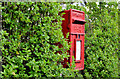
Letter box, Bangor
See Image (December 2009). The same box (BT20 292), on the Donaghadee Road near Grove Park, now being surrounded by suburban hedge.
Image: © Albert Bridge
Taken: 21 May 2013
0.07 miles
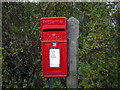
2
Pressed-steel postbox BT20 292, Bangor (July 2014)
See Image A post-mounted pressed-steel postbox on the Donaghadee Road, near Grove Park. It replaced this one Image (May 2013).
Image: © Albert Bridge
Taken: 15 Jul 2014
0.07 miles
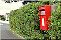
3
Postbox, Bangor
Post mounted Elizabeth II postbox on the Donaghadee Road in Bangor (BT20 868). Made by Carron of Falkirk .
Image: © Rossographer
Taken: 12 Dec 2009
0.08 miles
4
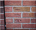
Bench Mark, Bangor
Cut bench mark on the Donaghadee Road in Bangor. There are two cut marks - perhaps the first was not quite accurate enough.
The mark is 11.86 metres above MSL.
See also http://www.geograph.org.uk/search.php?i=11037856 for many other examples I have found.
Image: © Rossographer
Taken: 13 Mar 2010
0.10 miles
5
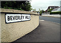
Beverley Hills, Bangor
One of several areas in Bangor named after famous American streets.
Beverley Hills was developed around the 1920s/1930s, coinciding with the American cinematic influences of the age. Marcus Patton http://www.worldcat.org/isbn/090045752X records that "the road was developed on the line of a lane that originally led to the farm of Samuel Johnson, whose wife Amy was a devotee of the silver screen".
Image: © Rossographer
Taken: 20 Jun 2009
0.11 miles
6
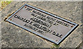
Thornleigh bus shelter plaque, Bangor
See Image The commemorative ground plaque which reads “The original brick shelter was presented by Alderman Charles F Milligan OBE January 1971”.
Image: © Albert Bridge
Taken: 21 May 2013
0.11 miles
7
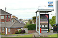
Bus shelter, Thornleigh, Bangor
A modern “Adshel” shelter at the Thornleigh (left) bus stop on the Donaghadee Road. Apparently it replaced a brick one – something which merits a commemorative plaque (to the right of the red seat) – see Image
Image: © Albert Bridge
Taken: 21 May 2013
0.11 miles
8
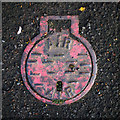
Air valve cover, Bangor
What appears to be an air valve cover on the Groomsport Road in Bangor. The cover is of a very similar size to Belfast Water Works covers such as Image
Image: © Rossographer
Taken: 17 Apr 2012
0.12 miles
9
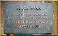
Plaque, Brice Park
Plaque in Brice Park Image recording that the land here was donated to the borough of Bangor by Frederick J. Brice JP and James F. Brice.
Image: © Rossographer
Taken: 20 Jun 2009
0.13 miles
10
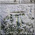
Bench Mark, Bangor
Cut bench mark located on a wall on the Groomsport Road in Bangor.
The mark is 8.64 metres above MSL.
Image: © Rossographer
Taken: 17 Apr 2012
0.13 miles