IMAGES TAKEN NEAR TO
Park Avenue, BANGOR, BT20 4JU
Introduction
This page details the photographs taken nearby to Park Avenue, BT20 4JU by members of the Geograph project.
The Geograph project started in 2005 with the aim of publishing, organising and preserving representative images for every square kilometre of Great Britain, Ireland and the Isle of Man.

There are currently over 7.5m images from over14,400 individuals and you can help contribute to the project by visiting https://www.geograph.org.uk
Image Map
Images are licensed for reuse under creativecommons.org/licenses/by-sa/2.0
Notes
- Clicking on the map will re-center to the selected point.
- The higher the marker number, the further away the image location is from the centre of the postcode.
Image Listing (532 Images Found)
Images are licensed for reuse under creativecommons.org/licenses/by-sa/2.0
Image
Details
Distance
1
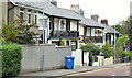
Park Drive, Bangor
A short street, between the Hamilton Road and Castle Street, laid out around 1920. Most of the houses in the photograph are said to date from about 1925 and feature balconies, verandahs and fancy cast ironwork.
Image: © Albert Bridge
Taken: 17 Sep 2013
0.02 miles
2
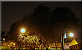
Edge of Ward Park by night
Looking from the park towards Park Drive with the town centre beyond.
Image: © Rossographer
Taken: 9 Dec 2007
0.03 miles
3
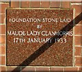
Foundation stone, Royal British Legion, Bangor
Detail of Image showing the foundation stone laid by Lady Clanmorris on the 17th January 1933.
Image: © Rossographer
Taken: 21 Sep 2008
0.04 miles
4
![Royal British Legion, Bangor [detail]](https://s2.geograph.org.uk/photos/97/35/973554_87148840_120x120.jpg)
Royal British Legion, Bangor [detail]
Stone commemorating the opening of the Royal British Legion in Bangor Image on the 1st July 1933.
Image: © Rossographer
Taken: 21 Sep 2008
0.04 miles
5
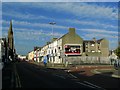
May Avenue, Bangor
A street, with a bend, running from Castle Street to the Hamilton Road (background). Developed about 1900 on what was then a rugby ground. Park Avenue is at lower right.
Image: © Albert Bridge
Taken: 15 Nov 2012
0.05 miles
6
Hamilton Road, Bangor
Looking along Hamilton Road towards the centre of Bangor. Mills Road runs off to the right.
Image: © Rossographer
Taken: 21 Sep 2008
0.05 miles
7
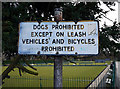
Sign, Ward Park
Ageing sign in Ward Park, Bangor - 'leash' is rarely used these days. The rules for dogs and bicycles are largely ignored. See also http://www.geograph.org.uk/search.php?i=10679719 for many related images of the same area.
Image: © Rossographer
Taken: 5 Feb 2010
0.06 miles
8
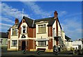
Royal British Legion, Bangor
Royal British Legion, Bangor branch, located on Hamilton Road. The foundation stone for the club was laid by Maude, Lady Clanmorris, on the 17th January 1933 Image and it was opened by Viscount Bangor on the 1st July 1933 Image
Image: © Rossographer
Taken: 21 Sep 2008
0.06 miles
9

Assembly Election Poster, Bangor
Carl McClean, Alan Chambers and Chris Eisenstadt, Ulster Unionist Party, at Hamilton Road, Bangor.
Image: © Rossographer
Taken: 1 May 2016
0.06 miles
10
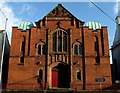
Dufferin Memorial Hall, Bangor
Memorial hall on Hamilton Road. It is squeezed in between other buildings on the street and photographs are awkward if, like me, you have no suitable wide angle lens.
The hall was built by local builder JH Savage to a design by Belfast firm Young & Mackenzie and opened in 1905. A memorial to the Marquess of Dufferin and Ava, the hall features the monogram DA above the door and coat-of-arms in the gable (see Image). Designed as a parish hall, it has served many purposes including a spell as the local court house during World War Two.
The hall is a memorial to Frederick Hamilton-Temple-Blackwood, 1st Marquess of Dufferin and Ava who died in 1902. The marquess had a varied and interesting life which included spells as Governor General of Canada from 1872 – 1878 and Viceroy of India from 1884 – 1888. See http://en.wikipedia.org/wiki/Frederick_Hamilton-Temple-Blackwood,_1st_Marquess_of_Dufferin_and_Ava for more information.
Image: © Rossographer
Taken: 5 Jun 2009
0.06 miles