IMAGES TAKEN NEAR TO
Main Street, BANGOR, BT20 4AA
Introduction
This page details the photographs taken nearby to Main Street, BT20 4AA by members of the Geograph project.
The Geograph project started in 2005 with the aim of publishing, organising and preserving representative images for every square kilometre of Great Britain, Ireland and the Isle of Man.

There are currently over 7.5m images from over14,400 individuals and you can help contribute to the project by visiting https://www.geograph.org.uk
Image Map
Images are licensed for reuse under creativecommons.org/licenses/by-sa/2.0
Notes
- Clicking on the map will re-center to the selected point.
- The higher the marker number, the further away the image location is from the centre of the postcode.
Image Listing (597 Images Found)
Images are licensed for reuse under creativecommons.org/licenses/by-sa/2.0
Image
Details
Distance
1
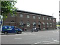
Post Office, Bangor
It is located along Main Street
Image: © Kenneth Allen
Taken: 25 Jun 2010
0.01 miles
2
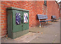
Telephone junction box, Bangor
Telephone junction box located outside the southern entrance to Bangor Post Office at the corner of Main Street and Castle Park Avenue. These boxes, first used by the General Post Office Telegraph Department (this one is marked GPO - see Image) and later by British Telecom, are still commonly found in the UK. Most are painted in this colour - known as GPO green - but some are also found in gray (there are examples in central Belfast). Recently some of these boxes in Bangor have been removed as part of the "BT Infinity" project which aims to increase broadband speeds in the area - new cables have been installed which presumably do not fit in the old boxes and larger modern replacements have been sited in their place.
Image: © Rossographer
Taken: 12 Oct 2010
0.01 miles
3
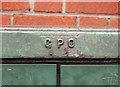
Telephone junction box, Bangor
Detail of the junction box seen in Image showing that it is marked GPO (General Post Office). Other examples are marked PO (Post Office), or even with the BT logo from the 1980s.
Image: © Rossographer
Taken: 12 Oct 2010
0.01 miles
4
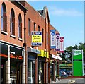
Market Street, Bangor
Formerly just a lane to Castle Square, the street was developed in the inter-war years. Damaged by a terrorist bomb in 1993, many of the buildings were demolished and reconstructed. Castle Square is now a supermarket car park but still hosts a sadly depleted market every Wednesday morning.
Image: © Rossographer
Taken: 8 Jul 2008
0.02 miles
6
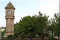
McKee clock, Bangor
Most towns have a distinctive landmark. In the case of Bangor it is the McKee clock, opposite the bottom of High Street in the sunken gardens. It was erected in 1915 being paid for by a council employee.
Image: © Albert Bridge
Taken: 4 Jun 2006
0.02 miles
7
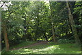
Castle Park, Bangor (1)
The Bangor castle and grounds were once the property of the Hamilton family. Both are now in municipal ownership. The castle is the town hall and the grounds are known as Castle Park. They still retain the feel of a private estate rather than a manicured public park. This leafy glade is adjacent to the town hall.
Image: © Albert Bridge
Taken: 21 Jun 2006
0.02 miles
8
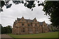
Bangor Town Hall
Bangor Town Hall was built as Bangor Castle in 1852 for Robert Ward. It was acquired by the Council in 1941 and became the Town Hall in 1952. It has an attractive setting in Castle Park (the former grounds). As well as the council chamber and offices it also contains a heritage centre.
Image: © Albert Bridge
Taken: 5 Aug 2006
0.02 miles
9
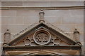
Bangor Town Hall (detail) (1)
This inscription is above the main entrance to Bangor Town Hall (formerly Bangor Castle).
Image: © Albert Bridge
Taken: 5 Aug 2006
0.02 miles
10
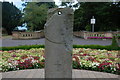
The Bangor sundial
The Bangor sundial is thought to date from around the year 900. It originated in Bangor Abbey. It has not survived too well and only five of the twelve timelines remain. It is displayed in front of the Town Hall.
Image: © Albert Bridge
Taken: 5 Aug 2006
0.02 miles