IMAGES TAKEN NEAR TO
Seacourt Lane, BANGOR, BT20 3TQ
Introduction
This page details the photographs taken nearby to Seacourt Lane, BT20 3TQ by members of the Geograph project.
The Geograph project started in 2005 with the aim of publishing, organising and preserving representative images for every square kilometre of Great Britain, Ireland and the Isle of Man.

There are currently over 7.5m images from over14,400 individuals and you can help contribute to the project by visiting https://www.geograph.org.uk
Image Map
Images are licensed for reuse under creativecommons.org/licenses/by-sa/2.0
Notes
- Clicking on the map will re-center to the selected point.
- The higher the marker number, the further away the image location is from the centre of the postcode.
Image Listing (216 Images Found)
Images are licensed for reuse under creativecommons.org/licenses/by-sa/2.0
Image
Details
Distance
1

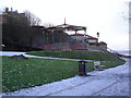
Steps, Bangor
A path running up from the main coastal path behind houses in Princetown Road. A very popular spot with teenage graffiti artists and cider drinkers. The high wall to the right hides the old and now converted house 'Seacourt' behind. Previously seen in 2008 Image
Image: © Rossographer
Taken: 3 Feb 2013
0.02 miles
2
![Modern houses, Seacourt Lane [2]](https://s0.geograph.org.uk/photos/59/36/593652_85887de6_120x120.jpg)
Modern houses, Seacourt Lane [2]
More modern housing - the Victorian 'Glenbank' poking out to the left is in stark contrast. Facing Image
Image: © Rossographer
Taken: 24 Oct 2007
0.02 miles
3
![Modern houses, Seacourt Lane [1]](https://s3.geograph.org.uk/photos/59/36/593651_41ad2d0c_120x120.jpg)
Modern houses, Seacourt Lane [1]
Very modern box-like houses.
Image: © Rossographer
Taken: 24 Oct 2007
0.03 miles
4
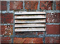
Ventilation grille, Bangor
Ventilation grille on the wall of a house at Seacourt Lane in Bangor. Marked "Carron" it probably came from the Carron Iron Works in Stirlingshire - see Image
Image: © Rossographer
Taken: 20 Apr 2011
0.03 miles
5
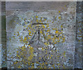
Bench Mark, Bangor
Cut bench mark on the right hand gate pier that leads into Seacourt on the Princetown Road in Bangor.
See also http://www.geograph.org.uk/search.php?i=11037856 for many other examples I have found.
Image: © Rossographer
Taken: 7 Mar 2010
0.04 miles
6

Manhole cover, Bangor
Detail of a manhole cover close to Wilson's Point in Bangor. Partially buried it is marked "Nevilles Aldridge" - further information welcomed.
Image: © Rossographer
Taken: 11 Jun 2011
0.05 miles
7
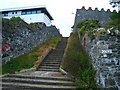
Steps at Seacourt Lane
These steps lead up from the coastal path. The extremely modern house on the left is in stark contrast to the wall on the right.
Image: © Rossographer
Taken: 7 Oct 2007
0.05 miles

9
Dilapidated bandstand, Bangor
This has become a bit of an eyesore - I'm not sure what plans the North Down Borough Council has for it - demolition most likely.
Image: © Dean Molyneaux
Taken: 22 Dec 2009
0.06 miles
10
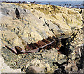
Shipwreck remains, Bangor
Over the years there have been many many shipwrecks in and around Belfast Lough. Many offshore wrecks remain, some almost intact, and can be dived. Most onshore wrecks were either refloated or salvaged for scrap and no trace of them remains. At Ballymacormick Point I found an old anchor from an unknown wreck Image and here, at Wilson's Point, can be seen some steelwork from another. This has been identified as the remains of the M.V. 'Oregon 1' which foundered here after dragging her anchors on the 4th January 1945; most of the ship was either salvaged or remains underwater just offshore, this section is visible at low tide. The vessel was built in Copenhagan in 1916 and, heading for Halifax, Nova Scotia from Newport, it had been waiting in Belfast Lough to join an Atlantic convey. See http://www.irishwrecksonline.net/Lists/DownNorthListA.htm for further information on wrecks in north County Down.
Image: © Rossographer
Taken: 7 Aug 2011
0.06 miles