Shipwreck remains, Bangor
Introduction
The photograph on this page of Shipwreck remains, Bangor by Rossographer as part of the Geograph project.
The Geograph project started in 2005 with the aim of publishing, organising and preserving representative images for every square kilometre of Great Britain, Ireland and the Isle of Man.

There are currently over 7.5m images from over 14,400 individuals and you can help contribute to the project by visiting https://www.geograph.org.uk
Shipwreck remains, Bangor
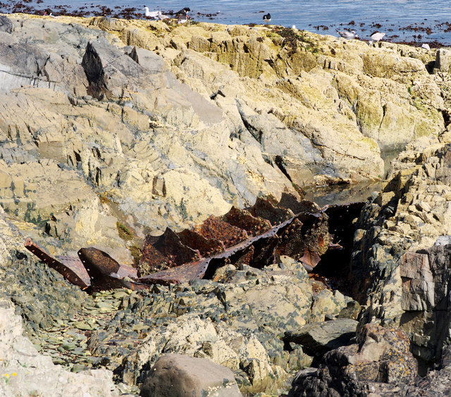
Image: © Rossographer Taken: 7 Aug 2011
Over the years there have been many many shipwrecks in and around Belfast Lough. Many offshore wrecks remain, some almost intact, and can be dived. Most onshore wrecks were either refloated or salvaged for scrap and no trace of them remains. At Ballymacormick Point I found an old anchor from an unknown wreck Image and here, at Wilson's Point, can be seen some steelwork from another. This has been identified as the remains of the M.V. 'Oregon 1' which foundered here after dragging her anchors on the 4th January 1945; most of the ship was either salvaged or remains underwater just offshore, this section is visible at low tide. The vessel was built in Copenhagan in 1916 and, heading for Halifax, Nova Scotia from Newport, it had been waiting in Belfast Lough to join an Atlantic convey. See http://www.irishwrecksonline.net/Lists/DownNorthListA.htm for further information on wrecks in north County Down.
Images are licensed for reuse under creativecommons.org/licenses/by-sa/2.0
Image Location
Latitude
54.668424
Longitude
-5.679043