IMAGES TAKEN NEAR TO
Princetown Road, BANGOR, BT20 3TA
Introduction
This page details the photographs taken nearby to Princetown Road, BT20 3TA by members of the Geograph project.
The Geograph project started in 2005 with the aim of publishing, organising and preserving representative images for every square kilometre of Great Britain, Ireland and the Isle of Man.

There are currently over 7.5m images from over14,400 individuals and you can help contribute to the project by visiting https://www.geograph.org.uk
Image Map
Images are licensed for reuse under creativecommons.org/licenses/by-sa/2.0
Notes
- Clicking on the map will re-center to the selected point.
- The higher the marker number, the further away the image location is from the centre of the postcode.
Image Listing (428 Images Found)
Images are licensed for reuse under creativecommons.org/licenses/by-sa/2.0
Image
Details
Distance
1
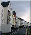
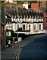
Princetown Avenue, Bangor
Mainly Victorian built avenue overlooking Bangor marina and harbour; the apartments on the left are a very recent addition.
Image: © Rossographer
Taken: 7 Mar 2008
0.04 miles
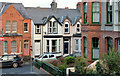
2
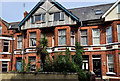
Nos 14&16 Princetown Road, Bangor
Part of a terrace, built circa 1900, known as “Clonallon”, currently vacant and offered for sale. The agent’s website describes them thus “We are offering No 14 and 16 Princetown Road, Bangor, for sale as one or two lots. The properties are a pair of adjoining terrace period homes which are in need of much renovation and restoration. They are located in a highly sought after area of the town, just minutes by foot from the Town Centre, Seafront, Coastal Paths and Marina. Once renovated these distinctive properties would provide excellent family homes. Alternatively consideration could be given to conversion to apartments subject to planning approvals”.
Image: © Albert Bridge
Taken: 14 Jun 2011
0.04 miles
3
Princetown Avenue, Bangor
A steep little street leading from Somerset Avenue (ahead, unseen) to Princetown Road. Laid out c1905, the block of apartments to the left has only just been constructed.
Image: © Rossographer
Taken: 2 Jun 2008
0.04 miles
4
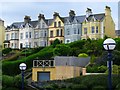
Mount Royal, Bangor
Fine terrace overlooking the harbour/marina area in Bangor. Built c1875, access is via the Princetown Road.
Image: © Rossographer
Taken: 8 Jul 2008
0.05 miles
5
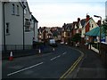
Princetown Road, Bangor
Looking along the road towards the black & white Ardmore Cottages. Built c1880, these cottages are relatively modest in scale compared with some of the grand villas eleswhere on the road.
Image: © Rossographer
Taken: 2 Jun 2008
0.05 miles
6
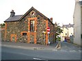
Stone House
This stone house off Princetown Road was renovated over several years. Now looking very well.
Image: © Rossographer
Taken: 24 Oct 2007
0.06 miles
7
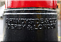
Victorian postbox, Bangor
Detail of Image - the box was cast by "A. Handyside and Co. Ltd., Derby and London". Andrew Handyside established his foundry in Derby in 1848. As well as being one of the first companies to produce the new standard Post Office letterboxes, it also produced a huge variety of other structures both in the UK and all over the world - see Image for a good example. After Handyside died in 1887 the firm began a rapid decline and closed in the 1920s.
Image: © Rossographer
Taken: 12 Mar 2011
0.07 miles
8

Victorian postbox, Bangor
Detail of the postbox on Princetown Road in Bangor seen in Image This is the royal VR cipher (or cypher).
Image: © Rossographer
Taken: 12 Mar 2011
0.07 miles
9
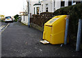
Grit box, Bangor
Grit box on Tennyson Avenue in Bangor.
Image: © Rossographer
Taken: 17 Jan 2010
0.07 miles
10
Princetown Avenue and Somerset Avenue, Bangor
Two streets off the beaten track and spared from through traffic. Princetown Avenue Image (June 2008) is in the foreground. Part of Somerset Avenue Image (June 2010) is in the background. The latter dates from 1880. Both are well secluded between Gray’s Hill and the Princetown Road. The Google map shows Princetown Avenue as “Church Lane”.
Image: © Albert Bridge
Taken: 4 Dec 2012
0.07 miles