IMAGES TAKEN NEAR TO
Bryansglen Avenue, BANGOR, BT20 3RU
Introduction
This page details the photographs taken nearby to Bryansglen Avenue, BT20 3RU by members of the Geograph project.
The Geograph project started in 2005 with the aim of publishing, organising and preserving representative images for every square kilometre of Great Britain, Ireland and the Isle of Man.

There are currently over 7.5m images from over14,400 individuals and you can help contribute to the project by visiting https://www.geograph.org.uk
Image Map
Images are licensed for reuse under creativecommons.org/licenses/by-sa/2.0
Notes
- Clicking on the map will re-center to the selected point.
- The higher the marker number, the further away the image location is from the centre of the postcode.
Image Listing (59 Images Found)
Images are licensed for reuse under creativecommons.org/licenses/by-sa/2.0
Image
Details
Distance
1
![Stricklands Glen, Bangor [3]](https://s0.geograph.org.uk/photos/71/14/711420_a6a89d76_120x120.jpg)
Stricklands Glen, Bangor [3]
A path into the glen. See also Image
Image: © Rossographer
Taken: 2 Mar 2008
0.06 miles
2
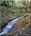
The Bryans Burn, Stricklands Glen
Bryans Burn river as it runs through Stricklands Glen.
Image: © Rossographer
Taken: 17 Jan 2010
0.08 miles
3
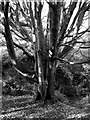
Tree, Stricklands Glen
I liked the shape of this tree, the colours of the fallen leaves around it and the light of the rising sun against it. Sadly I just can't seem to get my camera to capture complex coloured woodland scenes like that it an acceptable manner and it looks much better in black & white. I need a new camera - you use your imagination.
Image: © Rossographer
Taken: 2 Nov 2008
0.08 miles
4
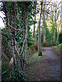
Path, Stricklands Glen
Path through Stricklands Glen in Bangor.
Image: © Rossographer
Taken: 17 Jan 2010
0.08 miles
5
![Stricklands Glen, Bangor [4]](https://s2.geograph.org.uk/photos/71/14/711426_b04caff8_120x120.jpg)
Stricklands Glen, Bangor [4]
As well as a path running directly through the glen, there is also a higher path that skirts the top and leads straight to the shore. See also Image
Image: © Rossographer
Taken: 2 Mar 2008
0.10 miles
6
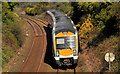
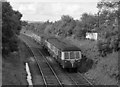
Railway at Bangor West
Set no 3006, rounding the sharp curve on the approach to Bangor West, with the 10.15 Portadown – Bangor.
Image: © Albert Bridge
Taken: 27 Mar 2012
0.12 miles
7
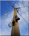
Telegraph pole, Bangor
Telegraph pole on the Bryansburn Road in Bangor. This example carries electricity cables and not telephone wires.
Image: © Rossographer
Taken: 17 Jan 2010
0.13 miles
8
MED set at Bangor West - 1975 (1)
A UTA built 3-car MED set approaches Bangor West station with a passenger service from Belfast (Queen's Quay) to Bangor.
Image: © The Carlisle Kid
Taken: 9 Aug 1975
0.13 miles
9
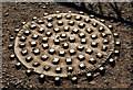
Millfield Foundry manhole cover, Bangor (1)
A manhole cover, on the Bryansburn Road, opposite Bryansglen, made by the Millfield Foundry, Belfast in 1931. Image shows the inscription and date.
Image: © Albert Bridge
Taken: 27 Mar 2012
0.13 miles
10
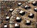
Millfield Foundry manhole cover, Bangor (2)
See Image The date of manufacture.
Image: © Albert Bridge
Taken: 27 Mar 2012
0.13 miles