IMAGES TAKEN NEAR TO
Brompton Road, BANGOR, BT20 3RE
Introduction
This page details the photographs taken nearby to Brompton Road, BT20 3RE by members of the Geograph project.
The Geograph project started in 2005 with the aim of publishing, organising and preserving representative images for every square kilometre of Great Britain, Ireland and the Isle of Man.

There are currently over 7.5m images from over14,400 individuals and you can help contribute to the project by visiting https://www.geograph.org.uk
Image Map
Images are licensed for reuse under creativecommons.org/licenses/by-sa/2.0
Notes
- Clicking on the map will re-center to the selected point.
- The higher the marker number, the further away the image location is from the centre of the postcode.
Image Listing (73 Images Found)
Images are licensed for reuse under creativecommons.org/licenses/by-sa/2.0
Image
Details
Distance
1

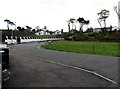
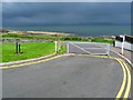
Brompton Road, Bangor
One end of Brompton Road, near the junction with Downshire Road. The road is a cul-de-sac and leads to the shore of Belfast Lough - see Image
Image: © Rossographer
Taken: 8 Jul 2008
0.04 miles
2

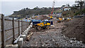
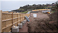
Construction site, Bangor
Construction site at the shoreline by Brompton in Bangor. Three modern dwellings are being constructed, replacing one bungalow. The walkers in the foreground are on the North Down Coastal Path heading towards Bangor.
Image: © Rossographer
Taken: 29 Apr 2019
0.06 miles
3
The seaward end of Brompton Road, Bangor
This image was taken from the coastal path.
Image: © Eric Jones
Taken: 20 May 2012
0.07 miles
4
Sewerage works, Bangor
Sewerage upgrade works at Brompton in Bangor which have now been going on for nearly a year - see Image from March 2020.
Image: © Rossographer
Taken: 2 Mar 2021
0.08 miles
5
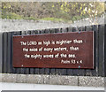
Religious message, Bangor
Bible quotation attached to a fence (facing the sea) at Brompton, Bangor.
Image: © Rossographer
Taken: 4 Nov 2016
0.08 miles
6
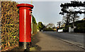
Pillar box, Bangor
See Image Possibly the same GR pillar box but on the Maxwell Road just past the corner of the Downshire Road.
Image: © Albert Bridge
Taken: 1 Dec 2011
0.08 miles
7
Sewerage works, Bangor
Sewerage upgrade works at Brompton in Bangor which have completely eradicated the green area seen in Image
Image: © Rossographer
Taken: 25 Mar 2020
0.08 miles
8
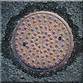
Manhole cover, Bangor
Manhole cover located on the North Down Coastal Path near Brompton Road in Bangor. It is marked "Adams Hydraulics - York London" as well as "Patent Conical Cover". I can't find too much out about Adams Limited, but they appear to have been involved in the water and sewage treatment industry and may still be trading as Ham Baker Adams / Adams Hydraulics - http://www.adamshydraulics.co.uk/ . Clarifications on the above welcomed.
Image: © Rossographer
Taken: 11 Jun 2011
0.09 miles
9
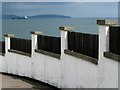
Wall and fence, Brompton Road, Bangor
Wall and fence at the bottom of Bompton Road (just unseen to the right of Image). Belfast Lough and the County Antrim coastline is beyond with the ship 'Mornes' at anchor, awaiting to passage to Kilroot Power Station.
Image: © Rossographer
Taken: 8 Jul 2008
0.09 miles
10
Brompton Road, Bangor
The end of the road from Image The North Down Coastal Path and shoreline of Belfast Lough lies beyond the gate.
Image: © Rossographer
Taken: 8 Jul 2008
0.09 miles