IMAGES TAKEN NEAR TO
Maxwell Drive, BANGOR, BT20 3PE
Introduction
This page details the photographs taken nearby to Maxwell Drive, BT20 3PE by members of the Geograph project.
The Geograph project started in 2005 with the aim of publishing, organising and preserving representative images for every square kilometre of Great Britain, Ireland and the Isle of Man.

There are currently over 7.5m images from over14,400 individuals and you can help contribute to the project by visiting https://www.geograph.org.uk
Image Map
Images are licensed for reuse under creativecommons.org/licenses/by-sa/2.0
Notes
- Clicking on the map will re-center to the selected point.
- The higher the marker number, the further away the image location is from the centre of the postcode.
Image Listing (109 Images Found)
Images are licensed for reuse under creativecommons.org/licenses/by-sa/2.0
Image
Details
Distance
1
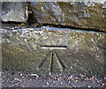
Bench Mark, Bangor
Cut bench mark at the foot of a wall in front of a house on the Maxwell Road in Bangor.
See also http://www.geograph.org.uk/search.php?i=11037856 for many other examples I have found.
Image: © Rossographer
Taken: 7 Mar 2010
0.04 miles

3
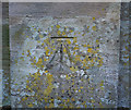
Bench Mark, Bangor
Cut bench mark on the right hand gate pier that leads into Seacourt on the Princetown Road in Bangor.
See also http://www.geograph.org.uk/search.php?i=11037856 for many other examples I have found.
Image: © Rossographer
Taken: 7 Mar 2010
0.08 miles
4
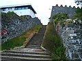
Steps at Seacourt Lane
These steps lead up from the coastal path. The extremely modern house on the left is in stark contrast to the wall on the right.
Image: © Rossographer
Taken: 7 Oct 2007
0.08 miles

6
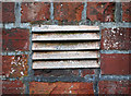
Ventilation grille, Bangor
Ventilation grille on the wall of a house at Seacourt Lane in Bangor. Marked "Carron" it probably came from the Carron Iron Works in Stirlingshire - see Image
Image: © Rossographer
Taken: 20 Apr 2011
0.08 miles
7
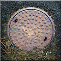
Manhole cover, Bangor
Manhole cover located on the North Down Coastal Path near Brompton Road in Bangor. It is marked "Adams" as well as "Patent Conical Cover". It is almost certainly from the firm Adams Hydraulics Ltd. I can't find too much out about Adams Limited, but they appear to have been involved in the water and sewage treatment industry and may still be trading as Ham Baker Adams / Adams Hydraulics - http://www.adamshydraulics.co.uk/ . Clarifications welcomed.
Image: © Rossographer
Taken: 11 Jun 2011
0.09 miles
8
![Modern houses, Seacourt Lane [2]](https://s0.geograph.org.uk/photos/59/36/593652_85887de6_120x120.jpg)
Modern houses, Seacourt Lane [2]
More modern housing - the Victorian 'Glenbank' poking out to the left is in stark contrast. Facing Image
Image: © Rossographer
Taken: 24 Oct 2007
0.10 miles
9

The North Down Coastal Path, Bangor
The North Down Coastal Path, looking towards Wilson’s Point, showing just how close it is to the sea.
Image: © Albert Bridge
Taken: 12 Aug 2008
0.10 miles
10
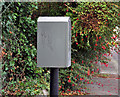
Drop box, Bangor
Drop box, with a fuchsia hedge background, near the northern end of the Princetown Road.
Image: © Albert Bridge
Taken: 15 Sep 2011
0.10 miles