IMAGES TAKEN NEAR TO
Clandeboye Road, BANGOR, BT20 3JU

Introduction

This page details the photographs taken nearby to Clandeboye Road, BT20 3JU by members of the Geograph project.

The Geograph project started in 2005 with the aim of publishing, organising and preserving representative images for every square kilometre of Great Britain, Ireland and the Isle of Man.

There are currently over 7.5m images from over14,400 individuals and you can help contribute to the project by visiting https://www.geograph.org.uk

Image Map


Images are licensed for reuse under creativecommons.org/licenses/by-sa/2.0
Notes
  • Clicking on the map will re-center to the selected point.
  • The higher the marker number, the further away the image location is from the centre of the postcode.

Image Listing (15 Images Found)

Images are licensed for reuse under creativecommons.org/licenses/by-sa/2.0
Image
Details
Distance
1
Dump Wood?
Signs like this appear all over Loyalist areas of Northern Ireland in the weeks before the 11th July, asking people to dump wood for bonfires. Unlike this example, most are usually spelled properly!
Image: © Rossographer Taken: 30 Jun 2007
0.02 miles
2
"Hartlid" manhole cover, Bangor
See Image Another triangular cover from the Hartley Sons & Co foundry, Stoke-on-Trent. Similar but not identical. The previous one carried the name “Mute”. This one is a “Hartlid”. Further information about the foundry’s history welcomed. On the Clandeboye Road just inward of Inglewood Park.
Image: © Albert Bridge Taken: 4 Feb 2011
0.07 miles
3
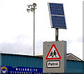
Solar panel, Bangor (2)
Solar panel powering the flashing lights on a “school” sign, outside Clandeboye Park football ground, on the Clandeboye Road.
Image: © Albert Bridge Taken: 4 Feb 2011
0.07 miles
4
Mural, Hazelbrook Avenue, Bangor
A mural on the side of a shop. It reflects some of the local history of the Clandeboye Road (now under the moniker of 'Clandeboye Village') area of the town.
Image: © Rossographer Taken: 2 May 2008
0.18 miles
5
Pillar box, Bangor
GVIR pillar box (BT20 588), on the Clandeboye Road, near the corner of Hazelbrook Avenue (out of picture to the left).
Image: © Albert Bridge Taken: 1 May 2012
0.18 miles
6
Ebenezer gospel hall, Bangor
The “Ebenezer” gospel hall, at the corner of Church Street and Hazelbrook Avenue (right). Built in 1932 and described as “Gabled roughcast hall four bays deep, with additional porch and side hall”. In this context "Ebenezer" is not a man’s name rather a translation from the Hebrew meaning "a rock of help". Image shows the new hall under construction on the other side of Church Street.
Image: © Albert Bridge Taken: 15 Oct 2011
0.19 miles
7
Church Street, Bangor
Looking along Church Street towards Bangor Abbey from near the junction with Clandeboye Road.
Image: © Rossographer Taken: 2 May 2008
0.21 miles
8
The new Ebenezer gospel hall, Bangor
See Image A new “Ebenezer” gospel hall is now under construction, nearby, on the other side of Church Street. Architect, Brian Payne Architects Limited. Image (January 2013) shows the completed hall.
Image: © Albert Bridge Taken: 15 Oct 2011
0.24 miles
9
Manhole cover, Bangor
Manhole cover located on Church Street in Bangor Image The cover was manufactured by Durey Castings http://www.dureycastings.co.uk/ .
Image: © Rossographer Taken: 2 May 2012
0.24 miles
10
The new Ebenezer gospel hall, Bangor (2)
See Image (October 2011). The completed hall.
Image: © Albert Bridge Taken: 1 Jan 2013
0.24 miles