IMAGES TAKEN NEAR TO
Windsor Park, BANGOR, BT20 3DG
Introduction
This page details the photographs taken nearby to Windsor Park, BT20 3DG by members of the Geograph project.
The Geograph project started in 2005 with the aim of publishing, organising and preserving representative images for every square kilometre of Great Britain, Ireland and the Isle of Man.

There are currently over 7.5m images from over14,400 individuals and you can help contribute to the project by visiting https://www.geograph.org.uk
Image Map
Images are licensed for reuse under creativecommons.org/licenses/by-sa/2.0
Notes
- Clicking on the map will re-center to the selected point.
- The higher the marker number, the further away the image location is from the centre of the postcode.
Image Listing (229 Images Found)
Images are licensed for reuse under creativecommons.org/licenses/by-sa/2.0
Image
Details
Distance
1
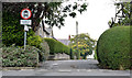
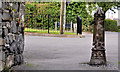
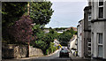
Windsor Park, Bangor
A narrow street, on the western side of the Manse Road (bottom) built, in the early 1930’s, on the site of what had once been allotments. The view is from Windsor Gardens Image
Image: © Albert Bridge
Taken: 1 Oct 2013
0.01 miles
2
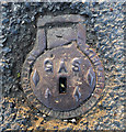
Old gas cover, Bangor
A small access cover marked 'Gas' located on Manse Road in Bangor. It almost certainly dates from when the town gas was produced and supplied in Bangor - this ended c1987.
The cover was cast by Hattersley and Davidson of Sheffield. This engineering company was established in 1894; the company still trades today as Hd Sports Ltd. http://www.hdsports.co.uk/hdsports-history.html but specialises in ice skating blades.
Image: © Rossographer
Taken: 2 May 2012
0.03 miles
3
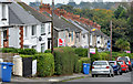
Windsor Gardens, Bangor
The northern side of a steep street, developed between 1928 and 1939, running from the Manse Road (behind me) towards a lane leading to Railwayview Street and the railway station.
Image: © Albert Bridge
Taken: 1 Oct 2013
0.06 miles
4
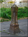
Bollard, Bangor
A very old cast-iron bollard at the end of Manse Road in Bangor. It has probably just been place here to prevent vehicles passing from the road onto a short lane which runs to the Brunswick Road. I believe that bollards of this style were once common in the town as they had been used in groups of 4 to surround gas lamps, protecting them from accidentical damage from passing carts or vehicles. The images at http://www.flickr.com/photos/adambangor/6057528496/in/set-72157605377535044/ & http://www.francisfrith.com/bangor,county-down/photos/bangor_40270/ show examples. No foundry name is visible, but it looks identical to an example seen in Lurgan cast by George Smith’s Sun Foundry, Glasgow Image
See also Image and Image for related images of the same bollard.
Image: © Rossographer
Taken: 2 May 2012
0.06 miles
5
Bollard, Bangor
A bollard, in the style of an old town-boundary post, at the end of the lane leading from Manse Road to this path Image and the Brunswick Road Image
Image: © Albert Bridge
Taken: 14 Jun 2011
0.06 miles
6
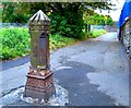
Victorian Cast Iron Obelisk
This sits at the end of Manse Road, marking where the road becomes pedestrian only. Surely the only example in Bangor!
Image: © Rossographer
Taken: 7 Oct 2007
0.07 miles
7
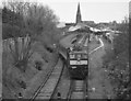
Locomotive hauled special train departing Bangor - 2003
As noted in other captions, the BCDR signal cabin at Bangor was demolished in November 1995 while the station was rebuilt in 2000. The new platform roofs can be seen in the background as NIR 111 class diesel locomotive No. 111 "Great Northern" pulls out of the station with a special train for the Irish Railway Record Society (http://www.irrs.ie/ ) .
Image: © The Carlisle Kid
Taken: 12 Apr 2003
0.08 miles
8
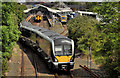
Train, Bangor
C4K set 4013 departing Bangor with the 13.57 to Portadown. This Image remains stored in the middle road. C3K set no 3004 is at platform 1 (right).
Image: © Albert Bridge
Taken: 30 May 2012
0.08 miles
9
Railway View Street, Bangor
A steepish street, built over a period from circa 1875 to the early 20th century, dropping from the Manse Road to Dufferin Avenue (hidden to the left in the background). The railway station http://www.geograph.org.uk/search.php?i=22301863 is the bright spot in the trees towards the middle right.
Image: © Albert Bridge
Taken: 14 Jun 2011
0.08 miles
10
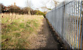
Railway path, Bangor (1)
Image: © Albert Bridge
Taken: 2 Mar 2010
0.08 miles