IMAGES TAKEN NEAR TO
Railwayview Street, BANGOR, BT20 3BZ
Introduction
This page details the photographs taken nearby to Railwayview Street, BT20 3BZ by members of the Geograph project.
The Geograph project started in 2005 with the aim of publishing, organising and preserving representative images for every square kilometre of Great Britain, Ireland and the Isle of Man.

There are currently over 7.5m images from over14,400 individuals and you can help contribute to the project by visiting https://www.geograph.org.uk
Image Map
Images are licensed for reuse under creativecommons.org/licenses/by-sa/2.0
Notes
- Clicking on the map will re-center to the selected point.
- The higher the marker number, the further away the image location is from the centre of the postcode.
Image Listing (490 Images Found)
Images are licensed for reuse under creativecommons.org/licenses/by-sa/2.0
Image
Details
Distance
1
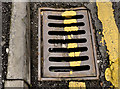
Millfield Foundry grating cover, Bangor
See Image An identical Millfield Foundry grating cover, on the other side of Railwayview Street but with the date (1923) partly hidden by the double yellow lines.
Image: © Albert Bridge
Taken: 1 Dec 2011
0.02 miles
2
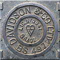
Manhole cover, Bangor
Detail of another Davidson manhole cover similar to Image and Image
This one is in a car park at Dufferin Avenue, Bangor Image
Image: © Rossographer
Taken: 2 May 2012
0.03 miles
3
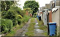
Lane, Bangor
A lane on the southern side of Railwayview Street. Not shown on the 1:10,000 street map or the Google map.
Image: © Albert Bridge
Taken: 30 May 2012
0.04 miles
4
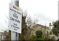
Car park, Dufferin Avenue, Bangor (2)
See Image A sign confirming that the car park is free.
Image: © Albert Bridge
Taken: 5 Mar 2014
0.04 miles
5
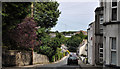
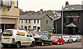
Railway View Street, Bangor
A steepish street, built over a period from circa 1875 to the early 20th century, dropping from the Manse Road to Dufferin Avenue (hidden to the left in the background). The railway station http://www.geograph.org.uk/search.php?i=22301863 is the bright spot in the trees towards the middle right.
Image: © Albert Bridge
Taken: 14 Jun 2011
0.04 miles
6
Catherine Place, Bangor (March 2014)
The site is currently used as an unofficial car park. The agent’s board (background) now has a “sold” patch. Dufferin Avenue is to the right.
Image: © Albert Bridge
Taken: 5 Mar 2014
0.04 miles
7
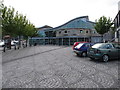
Bus and train station at Bangor
Bangor is the terminus of the line from Belfast Central along the shores of Belfast Lough
Image: © Eric Jones
Taken: 20 May 2012
0.05 miles
8
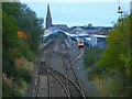
Bangor Railway Station
As viewed from the Boyne Bridge over Brunswick Road.
Image: © Rossographer
Taken: 7 Oct 2007
0.05 miles
9
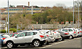
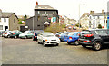
Car park, Dufferin Avenue, Bangor (1)
See Image Originally free and busy, the public car park at Dufferin Avenue (officially Dufferin Square) was converted to “pay and display” in 2013. Drivers seemed to shun it after introduction of the charge. It became free again – in the words of an official announcement (December 2013) “I am aware there is a significant, and growing, demand for Park and Ride facilities in Bangor and that the current Park and Ride site on Abbey Street is operating at capacity. I am also aware this growing demand has led to difficulties regarding parking around train halts along the railway line between Bangor and Belfast. I have subsequently concluded that the conversion of the existing Dufferin Avenue car park to a Park & Ride facility represents the best, and most immediate, solution.” See also Image The railway/bus station Image is at top left.
Image: © Albert Bridge
Taken: 5 Mar 2014
0.05 miles
10
Apartments site, Bangor (1)
The view from Dufferin Avenue towards Railwayview Street. Image shows the completed development.
Image: © Albert Bridge
Taken: 1 May 2012
0.05 miles