IMAGES TAKEN NEAR TO
Lower Balloo Road, BANGOR, BT19 6LU
Introduction
This page details the photographs taken nearby to Lower Balloo Road, BT19 6LU by members of the Geograph project.
The Geograph project started in 2005 with the aim of publishing, organising and preserving representative images for every square kilometre of Great Britain, Ireland and the Isle of Man.

There are currently over 7.5m images from over14,400 individuals and you can help contribute to the project by visiting https://www.geograph.org.uk
Image Map
Images are licensed for reuse under creativecommons.org/licenses/by-sa/2.0
Notes
- Clicking on the map will re-center to the selected point.
- The higher the marker number, the further away the image location is from the centre of the postcode.
Image Listing (12 Images Found)
Images are licensed for reuse under creativecommons.org/licenses/by-sa/2.0
Image
Details
Distance
1
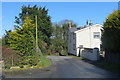
Near Groomsport
House on the Kylestone Road.
Image: © Robert Ashby
Taken: 10 Mar 2016
0.03 miles
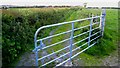
2
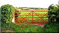
Red Gate
A freshly painted red gate on the Lower Balloo road, just at the junction with the Kylestone Road.
Many wrought iron gates have been replaced with galvanised steel, so it's nice to see an original being preserved.
Image: © Rossographer
Taken: 9 Jun 2007
0.08 miles
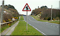
3
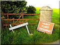
Kylestone Road
Kylestone Road, at the junction with Lower Balloo Road.
The HEAVY PLANT CROSSING sign refers to the huge earth works further down the road, connected with the laying of new sewage treatment works pipelines.
Image: © Rossographer
Taken: 9 Jun 2007
0.08 miles
4
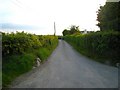
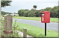
Lower Balloo Road
Looking up the Lower Balloo Road. The edge of Bangor is about 1 mile away
Image: © Rossographer
Taken: 9 Jun 2007
0.08 miles
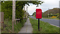
5
Pressed-steel postbox (BT19 100), Balloo Lower, Groomsport (August 2016)
A new post-mounted EIIR pressed-steel postbox (BT19 100) beside the Donaghadee Road.
Image: © Albert Bridge
Taken: 7 Aug 2016
0.12 miles
6
Postbox near Groomsport
Post mounted pressed steel Elizabeth II postbox on the A2 between Groomsport and Orlock (BT19 100). See also Image
Image: © Rossographer
Taken: 23 Apr 2020
0.13 miles
7
McIlwaine Lane
This is an actual public road - McIlwaine Lane that leads from the Lower Balloo Road to the A2 near Groomsport.
The road does not have a gate but a local farmer has a habit of tying his gate from the field next across the road to prevent people getting down!
Image: © Rossographer
Taken: 9 Jun 2007
0.15 miles
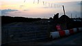
8
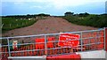
Earthworks on the Lower Balloo Road
This huge operation is part of new water treatment works in Donaghadee - it covers an underground pipe leading to Briggs Rocks near Groomsport
Image: © Rossographer
Taken: 9 Jun 2007
0.15 miles
9
Earthworks on the Lower Balloo Road
Another view of the earthworks on the Lower Balloo Road
Image: © Rossographer
Taken: 9 Jun 2007
0.15 miles
10
Staggered crossroads sign near Groomsport
Staggered crossroads sign on the Donaghadee Road, Groomsport. The Orlock Road is on the left and the Lower Balloo Road on the right.
Image: © Albert Bridge
Taken: 9 Apr 2010
0.19 miles