IMAGES TAKEN NEAR TO
Springwell Gardens, BANGOR, BT19 6LQ
Introduction
This page details the photographs taken nearby to Springwell Gardens, BT19 6LQ by members of the Geograph project.
The Geograph project started in 2005 with the aim of publishing, organising and preserving representative images for every square kilometre of Great Britain, Ireland and the Isle of Man.

There are currently over 7.5m images from over14,400 individuals and you can help contribute to the project by visiting https://www.geograph.org.uk
Image Map
Images are licensed for reuse under creativecommons.org/licenses/by-sa/2.0
Notes
- Clicking on the map will re-center to the selected point.
- The higher the marker number, the further away the image location is from the centre of the postcode.
Image Listing (90 Images Found)
Images are licensed for reuse under creativecommons.org/licenses/by-sa/2.0
Image
Details
Distance
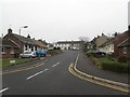
2
Gull and lamppost, Groomsport
This seems to be a juvenile herring gull perched on a lamppost on the Donaghadee Road.
Image: © Albert Bridge
Taken: 25 Apr 2013
0.05 miles
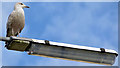
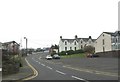
3
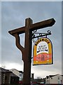
Time to move on?
This 15 year old sign hangs outside the 'Stables' restaurant in Groomsport.
Image: © Rossographer
Taken: 24 Nov 2007
0.05 miles
4
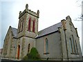
Groomsport Parish Church
Small church, built in 1842. There is no graveyard and very limited grounds around it.
Image: © Rossographer
Taken: 24 Nov 2007
0.06 miles
5
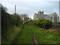
Track, Groomsport
This little track leads from the beach at Groomsport up to the main street.
Image: © Rossographer
Taken: 24 Nov 2007
0.06 miles
6
Springwell Drive, Groomsport
At the top of the hill is the Groomsport Primary School.
Image: © Eric Jones
Taken: 28 Mar 2017
0.07 miles
7
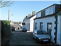
Canadian Consul, Groomsport
The Canadian Consul for Northern Ireland is housed in 35 The Hill, Groomsport (the end terrace house on the right). I didn't expect to find it here!
Image: © Rossographer
Taken: 17 Mar 2008
0.08 miles
8
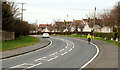
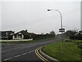
The Groomsport bypass
Just under a mile long, the Groomsport bypass runs from the end of the Bangor ring road to the Donaghadee Road Image Not the world’s busiest road but it does take traffic away from the Main Street Image
Image: © Albert Bridge
Taken: 9 Apr 2010
0.08 miles
10
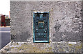
Flush Bracket, Groomsport
Flush bracket on the eastern wall of Groomsport parish church Image
The number on the bracket is OSBM 3466.
The mark is 10.33 metres above MSL.
There is apparently a second bench mark on the church but I could find no trace of it.
A flush bracket is a type of bench mark set onto the face of a building. See also http://www.geograph.org.uk/search.php?i=11037856 for many other examples I have found.
Image: © Rossographer
Taken: 21 Mar 2010
0.09 miles