IMAGES TAKEN NEAR TO
Crawfordsburn Lane, BANGOR, BT19 1ZR
Introduction
This page details the photographs taken nearby to Crawfordsburn Lane, BT19 1ZR by members of the Geograph project.
The Geograph project started in 2005 with the aim of publishing, organising and preserving representative images for every square kilometre of Great Britain, Ireland and the Isle of Man.

There are currently over 7.5m images from over14,400 individuals and you can help contribute to the project by visiting https://www.geograph.org.uk
Image Map
Images are licensed for reuse under creativecommons.org/licenses/by-sa/2.0
Notes
- Clicking on the map will re-center to the selected point.
- The higher the marker number, the further away the image location is from the centre of the postcode.
Image Listing (28 Images Found)
Images are licensed for reuse under creativecommons.org/licenses/by-sa/2.0
Image
Details
Distance
1

Bangor West station, Northern Ireland Railways
The Belfast and County Down Railway opened a station at Bangor West in 1928 to cater for the expanding population in the area. The railway remains a favourite way of travelling to work in Belfast. The photo shows returning commuters alighting from the 17.05 Belfast (Gt. Victoria St) - Bangor.
Image: © Albert Bridge
Taken: 28 Jun 2006
0.01 miles
2
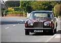
Car, Bangor
A Rolls Royce 'Silver Shadow II' (produced 1977-1980) for sale and parked on the Crawfordsburn Road in Bangor.
Image: © Rossographer
Taken: 25 Mar 2012
0.09 miles
3
Crawfordsburn Road, Bangor
Looking towards the centre of Bangor from Carnalea.
Image: © Rossographer
Taken: 22 Mar 2008
0.09 miles
4

The West Church, Bangor
The West (Presbyterian) Church at Rathmore was built in 1963 to a design by W McK Davidson. Too late for the Festival of Britain, too early for the swinging sixties, it would look out of place in a mill village or market town centre but suits the (then) new suburbs well – overall not a bad piece of sixties architecture.
Image: © Albert Bridge
Taken: 27 Sep 2007
0.14 miles
5

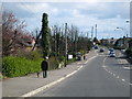
Autumn at Carnalea
A short wooded path which runs alongside the eastern edge of Carnalea Golf Club - I had not known of its existence until recently. The trees are mainly beech.
Image: © Rossographer
Taken: 2 Nov 2008
0.16 miles
6
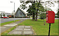
Letter box, Carnalea, Bangor
Post-mounted EIIR letter box at Worcester Avenue, off the Crawfordsburn Road. The West Church Image is in the background.
Image: © Albert Bridge
Taken: 15 Sep 2011
0.17 miles
7
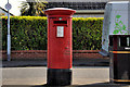
Pillar box, Bangor
This EIIR pillar box has the number BT20 93 and is outside the Bryansburn post office on the Rathmore Road, almost opposite Innisfayle Drive. The post office (inside a “Spar”) has the postcode BT19 1DL. The difference is attributable to the post code of the sorting office. My thanks to the Letter Box Study Group http://www.lbsg.org/ for the explanation.
Image: © Albert Bridge
Taken: 27 Mar 2012
0.18 miles
8
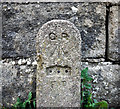
GPO cable marker, Bangor
Old GPO cable marker on the Bryansburn Road in Bangor.
This was placed by the General Post Office as a marker plate for their underground Cable network. Originally this would have had a plate giving the distance in feet and inches from post to the underground cable, but this has been removed. Often mistaken as bench marks, the arrow actually signifies that the GPO is a government department.
The following information was accessed at http://www.airfieldinformationexchange.org/community/showthread.php?2886-GPO-line-marker-post :
"Being a former GPO worker out in the field i can supply the following details.
The marker is indeed to indicate that there is a buried joint at the distance specified on the post. Usually the LEAD joint was 'found' in a small coffin approx. 2ft long and usually found at the bottom of a Telegraph pole, before the advent of boxes being constructed. Nowadays, what with H.& S. boxes are provided to prevent footpaths and the like being dug up.
In the sticks however, Lead cables usually ran a length of 151-154 yds and these markers were to be found in grass verges but these cables were 'Trunk cables' and somewhat larger (500prs cable as opposed to a 20-50pr cable), as such the 'coffin' was around 5ft in length. An absolute sod to dig out as they were usually quite deep as well. A manhole was provided at certain junctions to work on the larger joints and change-overs."
See also Image for a similar but older version of such a marker and also Image for a contemporary version.
Image: © Rossographer
Taken: 17 Apr 2010
0.19 miles
9
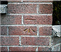
Bench Mark, Bangor
Cut bench mark on a garden wall at the corner of Westburn Crescent and the Bryansburn Road in Bangor.
The mark is 38.24 metres above MSL.
See also http://www.geograph.org.uk/search.php?i=11037856 for many other examples I have found.
Image: © Rossographer
Taken: 17 Apr 2010
0.20 miles
10
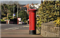
Pillar box, Bangor
GVIR pillar box (BT20 94), on the Bryansburn Road, close to the railway bridge and Westburn Crescent (background - right). Previously seen (with a short history) in Image January 2010.
Image: © Albert Bridge
Taken: 27 Mar 2012
0.20 miles