IMAGES TAKEN NEAR TO
Old Windmill Road, BANGOR, BT19 1XN
Introduction
This page details the photographs taken nearby to Old Windmill Road, BT19 1XN by members of the Geograph project.
The Geograph project started in 2005 with the aim of publishing, organising and preserving representative images for every square kilometre of Great Britain, Ireland and the Isle of Man.

There are currently over 7.5m images from over14,400 individuals and you can help contribute to the project by visiting https://www.geograph.org.uk
Image Map
Images are licensed for reuse under creativecommons.org/licenses/by-sa/2.0
Notes
- Clicking on the map will re-center to the selected point.
- The higher the marker number, the further away the image location is from the centre of the postcode.
Image Listing (153 Images Found)
Images are licensed for reuse under creativecommons.org/licenses/by-sa/2.0
Image
Details
Distance
1
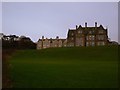
Crawford House
Built in 1906 this was home to the Crawford family and faces directly out onto Belfast Lough. In 1934 it was vacated by the Crawfords and turned into a TB hospital. After that it was turned into an old people's home before lying vacant for several years.
It is now part of an 'exclusive' housing development known as 'Sharman Estate' - the buildings in the background, known as 'Sharman House', are newer additions, built recently. Apparently Ian Paisley has an apartment here - see http://www.timesonline.co.uk/tol/newspapers/sunday_times/ireland/article626578.ece
Image: © Rossographer
Taken: 6 Dec 2007
0.04 miles
2
Former Crawfordsburn House, Crawfordsburn
Built in 1906 to replace one built in circa 1820 which replaced an earlier one of around 1780. Latterly it was Crawfordsburn Hospital and now (after conversion to apartments) is known as “Crawford House”. As the estate agents say “enjoys commanding views of Belfast Lough” (background). Note: taken from the grounds of Crawfordsburn Country Park. The house and grounds are well protected by the former estate wall.
Image: © Albert Bridge
Taken: 12 Feb 2009
0.09 miles
3
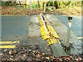
Traffic plates, Crawfordsburn Country Park
See Image Traffic plates on the (one-way) exit road allow outward traffic out but stop incoming vehicles.
Image: © Albert Bridge
Taken: 12 Feb 2009
0.09 miles
4
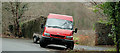
Minibus, Crawfordsburn Country Park
Conservation Volunteers Ford Transit minibus in Crawfordsburn Country Park.
Image: © Albert Bridge
Taken: 25 Jan 2011
0.10 miles
5
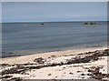
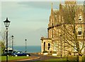
The beach at Swineley Bay
This is Greater Belfast's nearest equivalent to a tropical paradise.
Image: © Eric Jones
Taken: 20 May 2012
0.11 miles
6
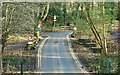
Two roads, Crawfordsburn Country Park
The exit road from the park Image as it approaches the Old Windmill Road.
Image: © Albert Bridge
Taken: 12 Feb 2009
0.11 miles
7
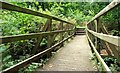
Footbridge, Crawfordsburn Country Park (2)
See Image The view across the same bridge.
Image: © Albert Bridge
Taken: 22 Sep 2009
0.11 miles
8
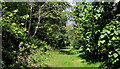
Path and trees, Crawfordsburn Country Park
A path, through the trees, on the western side of the Old Windmill Road, to the north of the field in Image
Image: © Albert Bridge
Taken: 31 May 2011
0.12 miles
9
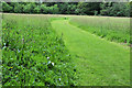
Mown path, Crawfordsburn Country Park
A path mown through a field in Crawfordsburn Country Park. The rest of the field has seed heads forming on the grass.
Image: © Albert Bridge
Taken: 19 May 2011
0.12 miles
10
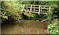
Footbridge, Crawfordsburn Country Park (1)
See Image There are several in the Park. This one is across the Crawfordsburn near road in. Continue to Image
Image: © Albert Bridge
Taken: 22 Sep 2009
0.12 miles