IMAGES TAKEN NEAR TO
Belfast Road, BANGOR, BT19 1UL
Introduction
This page details the photographs taken nearby to Belfast Road, BT19 1UL by members of the Geograph project.
The Geograph project started in 2005 with the aim of publishing, organising and preserving representative images for every square kilometre of Great Britain, Ireland and the Isle of Man.

There are currently over 7.5m images from over14,400 individuals and you can help contribute to the project by visiting https://www.geograph.org.uk
Image Map
Images are licensed for reuse under creativecommons.org/licenses/by-sa/2.0
Notes
- Clicking on the map will re-center to the selected point.
- The higher the marker number, the further away the image location is from the centre of the postcode.
Image Listing (19 Images Found)
Images are licensed for reuse under creativecommons.org/licenses/by-sa/2.0
Image
Details
Distance
1
![A2 Belfast Road near Bangor [2]](https://s3.geograph.org.uk/photos/80/29/802923_10d983ee_120x120.jpg)
A2 Belfast Road near Bangor [2]
The A2 road at Coach Hill Bend, looking in the Bangor direction.
Image: © Rossographer
Taken: 15 May 2008
0.06 miles
2
![A2 Belfast Road near Bangor [1]](https://s0.geograph.org.uk/photos/80/29/802916_2b256909_120x120.jpg)
A2 Belfast Road near Bangor [1]
Horrendously busy main A2 Bangor-Belfast Road near Ballygilbert. Looking in the Belfast direction this is the view at rush hour with the oncoming traffic heading towards Bangor.
Image: © Rossographer
Taken: 15 May 2008
0.13 miles
3
Meadow Way near Helen's Bay (1)
The start of Meadow Way, looking towards Helen’s Bay, just in from the Belfast Road at Ballygilbert.
Image: © Albert Bridge
Taken: 20 Sep 2010
0.13 miles
4
Fields close to the 'Jan Mayen Clump' near Bangor
Looking towards Image across fields close to Coach Hill Farm.
Image: © Rossographer
Taken: 15 May 2008
0.14 miles
5
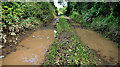
![Track near Bangor [1]](https://s3.geograph.org.uk/photos/80/31/803167_336e098e_120x120.jpg)
Track near Bangor [1]
Track into farmland off the main A2 dual carriageway near Coach Hill Farm.
Image: © Rossographer
Taken: 15 May 2008
0.18 miles
6
![Track near Bangor [2]](https://s2.geograph.org.uk/photos/80/31/803170_199086b6_120x120.jpg)
Track near Bangor [2]
Further along the track near Coach Hill Farm from Image
Image: © Rossographer
Taken: 15 May 2008
0.18 miles
7
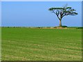
Field and tree near Bangor
The same tree as in Image but from a different angle, taken across a newly planted field.
Image: © Rossographer
Taken: 15 May 2008
0.18 miles
8
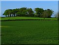
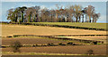
The 'Jan Mayen Clump' near Bangor
The 'Jan Mayen Clump' is one of a number of tree rings planted close to Bangor/Helen's Bay in the mid 19th Century - they are found close to Clandeboye Avenue http://www.geograph.org.uk/search.php?i=2710578 which runs from Clandeboye House to Helen's Bay. The trees were planted Lord Dufferin and commemorate many of the places he travelled to around the world. This clump is named after 'Jan Mayen Land' http://en.wikipedia.org/wiki/Jan_Mayen , a 35 mile long island in the Arctic Ocean which lies between Iceland and Spitzbergen - Lord Dufferin visited it during a voyage on his schooner 'Foam' c1856. Two similar features nearby are named the 'Niagara Clump', 'Ottawa Clump', 'Toronto Clump' and 'Montreal Clump' - these commemorate the years Lord Dufferin spent as Governor General of Canada.
The Environment and Heritage Service of Northern Ireland offer the following information taken from http://www.ehsni.gov.uk/content-databases-nismrview.htm?monid=6180 :
"A landscaping feature which encircles the summit of a rounded glacial knoll with fine views in all directions. This large site,110m in diam. is defined by an intermittent stone-faced bank which, where it survives, stands a uniform 1m above the cultivated exterior & 0.3m above the rough interior. A thorn hedge grows on the external edge of the bank for much of the perimeter. The interior is heavily planted with mostly mature, mixed deciduous trees. There are no signs of an earlier site on the hill top."
Image: © Rossographer
Taken: 15 May 2008
0.18 miles
9
The "Jan Mayen" clump near Helen's Bay (February 2014)
See Image and Image A distant view of the "Jan Mayen" Clump, a prominent and distinctive feature of the north Down landscape, from the Coothall Road.
Image: © Albert Bridge
Taken: 24 Feb 2014
0.19 miles
10
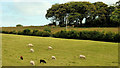
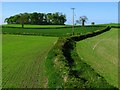
Field, Ballygilbert near Bangor (1)
Part of a large field, grazed by sheep, beside the Belfast Road at Ballygilbert. The Jan Mayen Clump Image is at top right. Meadow Way (Burnside Park on the Google map) is marked by the hedge line across the middle of the photograph.
Image: © Albert Bridge
Taken: 20 Sep 2010
0.19 miles