IMAGES TAKEN NEAR TO
Belfast Road, BANGOR, BT19 1UH
Introduction
This page details the photographs taken nearby to Belfast Road, BT19 1UH by members of the Geograph project.
The Geograph project started in 2005 with the aim of publishing, organising and preserving representative images for every square kilometre of Great Britain, Ireland and the Isle of Man.

There are currently over 7.5m images from over14,400 individuals and you can help contribute to the project by visiting https://www.geograph.org.uk
Image Map
Images are licensed for reuse under creativecommons.org/licenses/by-sa/2.0
Notes
- Clicking on the map will re-center to the selected point.
- The higher the marker number, the further away the image location is from the centre of the postcode.
Image Listing (17 Images Found)
Images are licensed for reuse under creativecommons.org/licenses/by-sa/2.0
Image
Details
Distance
1
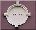
Ballygilbert Presbyterian church nr Bangor (2)
See Image The date of building.
Image: © Albert Bridge
Taken: 17 Feb 2011
0.05 miles
2
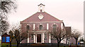
Ballygilbert Presbyterian church near Bangor (1)
A prominent sight on the road between Holywood and Bangor, particularly at night when floodlit, it was built in 1842.
Image: © Albert Bridge
Taken: 17 Feb 2011
0.05 miles
3
Clandeboye Avenue at Ballygilbert
See Image This is the view back to Helen’s Bay from where the avenue meets the Belfast-Bangor road.
Image: © Albert Bridge
Taken: 16 Sep 2006
0.11 miles
4
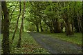
The Ulster Way in north Down (7)
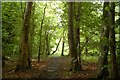
See Image The path is now coming to the edge of the square and the end of the thick border of trees. It is wider and the surface firmer making it look more like a motor track. This bit is very attractive with vegetation covering the ground and little or no sunshine finding its way through the trees.
Image: © Albert Bridge
Taken: 18 Jun 2007
0.11 miles
5
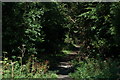
The Ulster Way in north Down (6)
See Image Having crossed the road (three minutes waiting for safe gaps in the traffic) the lane becomes narrower, the path is not quite so smooth and there is a greater feeling of being enclosed by the wood.
Image: © Albert Bridge
Taken: 18 Jun 2007
0.11 miles
6
The Ulster Way in north Down (5)
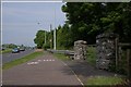
See Image This is the entrance to the path from the Belfast – Bangor road at Ballygilbert (looking towards Belfast) Image The next part of the path is on the other side of the dual carriageway – caution needed in crossing!
Image: © Albert Bridge
Taken: 18 Jun 2007
0.11 miles
7
Fields, Ballygilbert near Bangor
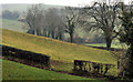
Fields and trees, on gentle drumlins, to the south western side of the Belfast Road, opposite Ballygilbert Presbyterian church Image
Image: © Albert Bridge
Taken: 17 Feb 2011
0.14 miles
8
Fungus, Helen's Bay (6)
Image: © Albert Bridge
Taken: 2 Sep 2008
0.14 miles
9
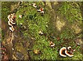
Fungus, Helen's Bay (7)
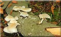
See Image Growing very close to the previous one – also on dead wood.
Image: © Albert Bridge
Taken: 2 Sep 2008
0.14 miles
10
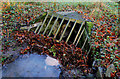
Culvert, Ballygilbert near Bangor
A culvert, partly hidden by fallen leaves, under Clandeboye Avenue.
Image: © Albert Bridge
Taken: 19 Nov 2010
0.15 miles