IMAGES TAKEN NEAR TO
Cargoes Crescent, BANGOR, BT19 1JB
Introduction
This page details the photographs taken nearby to Cargoes Crescent, BT19 1JB by members of the Geograph project.
The Geograph project started in 2005 with the aim of publishing, organising and preserving representative images for every square kilometre of Great Britain, Ireland and the Isle of Man.

There are currently over 7.5m images from over14,400 individuals and you can help contribute to the project by visiting https://www.geograph.org.uk
Image Map
Images are licensed for reuse under creativecommons.org/licenses/by-sa/2.0
Notes
- Clicking on the map will re-center to the selected point.
- The higher the marker number, the further away the image location is from the centre of the postcode.
Image Listing (45 Images Found)
Images are licensed for reuse under creativecommons.org/licenses/by-sa/2.0
Image
Details
Distance
1
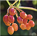
Red berries, Crawfordsburn (August 2017)
Red berries, with a passing resemblance to grapes, growing in Crawfordsburn Glen. Identification welcome.
Image: © Albert Bridge
Taken: 17 Aug 2017
0.04 miles
2
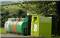
Recycling bins, Crawfordsburn
Recycling bins, at the Crawfordsburn Glen park car park, on the Cootehall Road.
Image: © Albert Bridge
Taken: 6 Sep 2012
0.06 miles
3
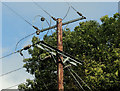
Overhead lines, Crawfordsburn
Overhead power lines, crossing Crawfordsburn Glen park, near the Cootehall Road.
Image: © Albert Bridge
Taken: 6 Sep 2012
0.06 miles
4
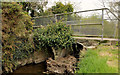
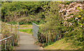
Footbridge, Crawfordsburn (1)
A footbridge across the Crawfordsburn, upstream of the country park, behind Main Street. One arch is partly blocked by debris washed down during wetter weather.
Image: © Albert Bridge
Taken: 25 Apr 2012
0.06 miles
5
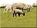
Sheep, Crawfordsburn (2)
Part of a flock grazing in fields to the south of Main Street.
Image: © Albert Bridge
Taken: 25 Apr 2012
0.08 miles
6
Footbridge, Crawfordsburn (2)
A footbridge, across the Crawfordsburn, downstream from this one Image
Image: © Albert Bridge
Taken: 25 Apr 2012
0.10 miles
7
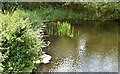
Old mill pond, Crawfordsburn (August 2017)
Part of the old mill pond, now very shallow, in Crawfordsburn Glen. The following quotation (a summary of information contained in the 1835 Ordnance Survey Memoirs) “Ballymullan is noted in the accompanying fair sheet for the 21 acres of mill pond and the corn mill belonging to Sharman Crawford MP. It has a large undershot wheel of 15 feet in diameter and 5 feet in breadth, bigger than many other similar mill-wheels as recorded” comes from the Bayburn local history website http://www.bayburn.com/.
Image: © Albert Bridge
Taken: 17 Aug 2017
0.10 miles
8
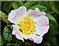
Dog rose Crawfordsburn (June 2019)
Dog rose growing close to the old mill pond - widespread http://www.habitas.org.uk/flora/map.asp?item=3401
Image: © Albert Bridge
Taken: 29 Jun 2019
0.10 miles
9
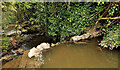
Weir, Crawfordsburn
A weir on the Crawfordsburn immediately downstream of here Image This is a short distance from Main Street after which the Crawfordsburn becomes the waterfall Image
Image: © Albert Bridge
Taken: 25 Apr 2012
0.11 miles
10
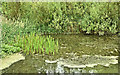
Old mill pond, Crawfordsburn (June 2019)
The old mill pond, in Crawfordsburn Glen, looking much as it did in this one Image
Image: © Albert Bridge
Taken: 29 Jun 2019
0.11 miles