IMAGES TAKEN NEAR TO
Elsinore Avenue, BANGOR, BT19 1EN
Introduction
This page details the photographs taken nearby to Elsinore Avenue, BT19 1EN by members of the Geograph project.
The Geograph project started in 2005 with the aim of publishing, organising and preserving representative images for every square kilometre of Great Britain, Ireland and the Isle of Man.

There are currently over 7.5m images from over14,400 individuals and you can help contribute to the project by visiting https://www.geograph.org.uk
Image Map
Images are licensed for reuse under creativecommons.org/licenses/by-sa/2.0
Notes
- Clicking on the map will re-center to the selected point.
- The higher the marker number, the further away the image location is from the centre of the postcode.
Image Listing (16 Images Found)
Images are licensed for reuse under creativecommons.org/licenses/by-sa/2.0
Image
Details
Distance
1
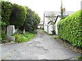
Downhill Avenue, Carnalea
A quiet and badly surfaced laneway off Killaire Park in Bangor's Carnalea area. Provides pedestrian access to Marlborough Park.
Image: © Dean Molyneaux
Taken: 16 Aug 2009
0.11 miles
2
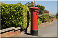
Pillar box, Carnalea, Bangor
EIIR pillar box (BT19 610), on the Station Road, close to Marlborough Drive (background).
Image: © Albert Bridge
Taken: 26 May 2012
0.20 miles
3
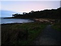
Bay near Crawfordsburn
This little bay sits between Crawfordsburn Country Park and Carnalea.
This is the view towards Carnalea - the little bit of land in the distance in the top left is actually one of the Copeland Islands.
Image: © Rossographer
Taken: 6 Dec 2007
0.20 miles
4
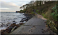
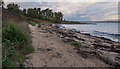
The North Down Coastal Path at Swineley Bay
The path at the east end of Swineley Bay. Here the path ends the beach on a large concrete section (usually very slippery so care must be taken) which then connects, via a short but very steep and uneven hill, with the man-made tarmac surface towards Carnalea.
Image: © Rossographer
Taken: 22 Nov 2022
0.21 miles
5
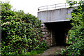
Railway bridge near Crawfordsburn
This bridge carries the Belfast (right) – Bangor railway across a farm track. The fence, just visible at bottom right, marks the boundary of Crawfordsburn Country Park.
Image: © Albert Bridge
Taken: 19 May 2011
0.21 miles
6
The North Down Coastal Path at Swineley Bay
The path at Swineley Bay. Here the path follows the top of the short beach for approximately 300m and is the only natural surface between Bangor and Helen's Bay.
Image: © Rossographer
Taken: 22 Nov 2022
0.21 miles
7
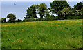
Field and trees near Crawfordsburn
The field at the end of the track in Image Belfast Lough is in the background.
Image: © Albert Bridge
Taken: 19 May 2011
0.21 miles
8
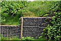
Gabions near Crawfordsburn
Gabions, between the railway embankment (background) and the farm track seen in Image
Image: © Albert Bridge
Taken: 19 May 2011
0.21 miles
9
![Mural, Carnalea railway halt [2]](https://s3.geograph.org.uk/photos/79/57/795755_055e56a1_120x120.jpg)
Mural, Carnalea railway halt [2]
Looking along more of the mural seen in Image
Image: © Rossographer
Taken: 9 May 2008
0.21 miles
10
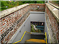
Steps, Carnalea railway halt
Steps leading from the platform down to the underpass seen in Image
Image: © Rossographer
Taken: 9 May 2008
0.21 miles