IMAGES TAKEN NEAR TO
Rutherglen Gardens, BANGOR, BT19 1DY
Introduction
This page details the photographs taken nearby to Rutherglen Gardens, BT19 1DY by members of the Geograph project.
The Geograph project started in 2005 with the aim of publishing, organising and preserving representative images for every square kilometre of Great Britain, Ireland and the Isle of Man.

There are currently over 7.5m images from over14,400 individuals and you can help contribute to the project by visiting https://www.geograph.org.uk
Image Map
Images are licensed for reuse under creativecommons.org/licenses/by-sa/2.0
Notes
- Clicking on the map will re-center to the selected point.
- The higher the marker number, the further away the image location is from the centre of the postcode.
Image Listing (37 Images Found)
Images are licensed for reuse under creativecommons.org/licenses/by-sa/2.0
Image
Details
Distance
1
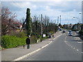
Crawfordsburn Road, Bangor
Looking towards the centre of Bangor from Carnalea.
Image: © Rossographer
Taken: 22 Mar 2008
0.06 miles
2
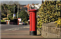
Pillar box, Bangor
GVIR pillar box (BT20 94), on the Bryansburn Road, close to the railway bridge and Westburn Crescent (background - right). Previously seen (with a short history) in Image January 2010.
Image: © Albert Bridge
Taken: 27 Mar 2012
0.09 miles
3
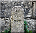
GPO cable marker, Bangor
Old GPO cable marker on the Bryansburn Road in Bangor.
This was placed by the General Post Office as a marker plate for their underground Cable network. Originally this would have had a plate giving the distance in feet and inches from post to the underground cable, but this has been removed. Often mistaken as bench marks, the arrow actually signifies that the GPO is a government department.
The following information was accessed at http://www.airfieldinformationexchange.org/community/showthread.php?2886-GPO-line-marker-post :
"Being a former GPO worker out in the field i can supply the following details.
The marker is indeed to indicate that there is a buried joint at the distance specified on the post. Usually the LEAD joint was 'found' in a small coffin approx. 2ft long and usually found at the bottom of a Telegraph pole, before the advent of boxes being constructed. Nowadays, what with H.& S. boxes are provided to prevent footpaths and the like being dug up.
In the sticks however, Lead cables usually ran a length of 151-154 yds and these markers were to be found in grass verges but these cables were 'Trunk cables' and somewhat larger (500prs cable as opposed to a 20-50pr cable), as such the 'coffin' was around 5ft in length. An absolute sod to dig out as they were usually quite deep as well. A manhole was provided at certain junctions to work on the larger joints and change-overs."
See also Image for a similar but older version of such a marker and also Image for a contemporary version.
Image: © Rossographer
Taken: 17 Apr 2010
0.09 miles
4
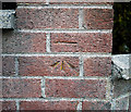
Bench Mark, Bangor
Cut bench mark on a garden wall at the corner of Westburn Crescent and the Bryansburn Road in Bangor.
The mark is 38.24 metres above MSL.
See also http://www.geograph.org.uk/search.php?i=11037856 for many other examples I have found.
Image: © Rossographer
Taken: 17 Apr 2010
0.10 miles
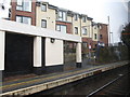
5
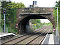
Bangor West railway station
Looking beyond the platforms towards the track in the Belfast direction. The bridge carries the Bryansburn Road over the track.
Image: © Rossographer
Taken: 2 May 2008
0.11 miles
6
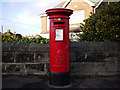
Postbox, Bangor
George VI postbox on the Bryansburn Road in Bangor (BT20 94). For many years this box stood on the opposite side of the street outside what was then Bryansburn Post Office. With the closure of the post office a few years ago, the Royal Mail decided to do away with the postbox as well. Cue public uproar, letters to the local MP & newspaper, rally in the town centre etc. Royal Mail backs down almost immediately and relocates the box - albeit across the street to this location (probably good thinking - the old PO has been knocked down and redeveloped, this box would have been in the way).
Image: © Rossographer
Taken: 17 Jan 2010
0.11 miles
7
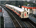
Bangor West station - 1988
The basic brick shelter seen at right replaced the original BCDR building in 1978. Everything in this scene is dressed in Northern Ireland Railways' "Suburban" colours, which was applied to Bangor line structures (and some 80-class DEMU sets) from 1987 to 1991. The train is the 09.55 passenger service from Bangor to Portadown.
Image: © The Carlisle Kid
Taken: 19 Mar 1988
0.12 miles
8
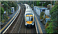
Bangor West station (4)
The winter light was failing as the 15.27 Bangor – Portadown (3018) stopped at Bangor West. It calls at all station to Gt Victoria Street and omits the intermediate stations between there and Lisburn. There is a local connection, from Gt Victoria Street, at 16.23.
Image: © Albert Bridge
Taken: 4 Dec 2012
0.12 miles
9
Platform 1 at Bangor West Railway Station
Image: © Eric Jones
Taken: 28 Mar 2017
0.12 miles
10
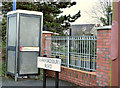
Telephone box, Bangor West
Telephone box, on the road overbridge, at Bangor West station Image
Image: © Albert Bridge
Taken: 4 Dec 2012
0.12 miles