IMAGES TAKEN NEAR TO
Church Road, HOLYWOOD, BT18 9RN
Introduction
This page details the photographs taken nearby to Church Road, BT18 9RN by members of the Geograph project.
The Geograph project started in 2005 with the aim of publishing, organising and preserving representative images for every square kilometre of Great Britain, Ireland and the Isle of Man.

There are currently over 7.5m images from over14,400 individuals and you can help contribute to the project by visiting https://www.geograph.org.uk
Image Map
Images are licensed for reuse under creativecommons.org/licenses/by-sa/2.0
Notes
- Clicking on the map will re-center to the selected point.
- The higher the marker number, the further away the image location is from the centre of the postcode.
Image Listing (19 Images Found)
Images are licensed for reuse under creativecommons.org/licenses/by-sa/2.0
Image
Details
Distance
1
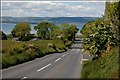
The Church Road near Holywood (1)
The Church Road runs off the Ballymiscaw Road towards Holywood. It descends steeply, giving good views across to the Co Antrim side of Belfast Lough.
Image: © Albert Bridge
Taken: 28 May 2007
0.14 miles
2
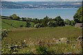
The Church Road near Holywood (2)
See Image This is the view, approximately to the west, from the road, looking over to the Co Antrim side of Belfast Lough.
Image: © Albert Bridge
Taken: 28 May 2007
0.14 miles
3
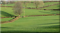
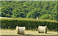
Fields and hedges, Ballykeel, Holywood (2)
Fields, divided by well-trimmed hedges, to the north/north east of the Church Road.
Image: © Albert Bridge
Taken: 13 Dec 2013
0.15 miles
4
![Fields near Holywood [2]](https://s3.geograph.org.uk/photos/82/43/824355_b3b3fc9e_120x120.jpg)
Fields near Holywood [2]
More fields near Holywood as viewed from near the top of Church Road.
Image: © Rossographer
Taken: 30 May 2008
0.17 miles
5
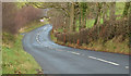
The Church Road, Holywood (7)
The Church Road climbing the steep hill Image, past Donaldson’s Lake Image (hidden left), towards the Ballymiscaw Road.
Image: © Albert Bridge
Taken: 13 Dec 2013
0.18 miles
6
Hay bales, Ballykeel, Holywood (June 2018)
Hay bales to the south western side of the Church Road. The current spell of dry weather must have been a great help to farmers.
Image: © Albert Bridge
Taken: 28 Jun 2018
0.18 miles
7
![Fields near Holywood [1]](https://s2.geograph.org.uk/photos/82/43/824350_cbd086ce_120x120.jpg)
Fields near Holywood [1]
Fields off the Church Road above Holywood. The Moss Road runs along the ridge in the distance and you can just make out a small part of Belfast Lough and some of the Co Antrim coastline beyond.
Image: © Rossographer
Taken: 30 May 2008
0.18 miles
8
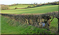
Hedge, Holywood
See Image Part of the same hedge, in this square, close to the Church Road.
Image: © Albert Bridge
Taken: 13 Dec 2013
0.19 miles
9
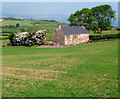
Fields and ruin near Holywood
An old ruin and trees in farmland off the Church Road above Holywood.
Image: © Rossographer
Taken: 30 May 2008
0.19 miles
10
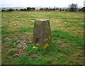
Standard Hill Triangulation Pillar
Trig pillar situated on a hill between Holywood and Dundonald in north County Down. The pillar lies in a field accessed from Church Road and is in excellent condition, although it has been partially buried - an earlier picture at http://www.trigpointing-ireland.org.uk/one_image.php?i=278 shows the full pillar. On a clear day the views are excellent in all directions. See also Image and Image I am unsure why this has been named 'Standard Hill' as I can find no trace of that name on any map. The townland is Ballykeel.
Image: © Rossographer
Taken: 22 Feb 2011
0.20 miles