IMAGES TAKEN NEAR TO
Clive Road, HOLYWOOD, BT18 9RF
Introduction
This page details the photographs taken nearby to Clive Road, BT18 9RF by members of the Geograph project.
The Geograph project started in 2005 with the aim of publishing, organising and preserving representative images for every square kilometre of Great Britain, Ireland and the Isle of Man.

There are currently over 7.5m images from over14,400 individuals and you can help contribute to the project by visiting https://www.geograph.org.uk
Image Map
Images are licensed for reuse under creativecommons.org/licenses/by-sa/2.0
Notes
- Clicking on the map will re-center to the selected point.
- The higher the marker number, the further away the image location is from the centre of the postcode.
Image Listing (17 Images Found)
Images are licensed for reuse under creativecommons.org/licenses/by-sa/2.0
Image
Details
Distance
1
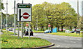
Direction sign, Holywood (May 2018)
A direction sign, on the Belfast Road, approaching the end of the Holywood bypass. Traffic from the Belfast direction may turn right, across the dual carriageway, to enter Holywood town. Traffic from Holywood, going towards Bangor, must proceed to the flyover at the Holywood Exchange Image Jackson’s Road is at the bottom.
Image: © Albert Bridge
Taken: 5 May 2018
0.13 miles
2
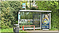
Bus shelter, Holywood (May 2018)
The Jackson’s Road stop and shelter on the Belfast Road. Served by the Ulsterbus Bangor - Belfast buses Image and Image
Image: © Albert Bridge
Taken: 5 May 2018
0.14 miles
3
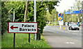
MoD direction sign, Holywood (May 2018)
Red-bordered advance direction sign, for Palace Barracks Image, on the Belfast Road, approaching Jackson’s Road. Back in the 1970’s there was an entrance, now closed, from the Belfast Road.
Image: © Albert Bridge
Taken: 5 May 2018
0.16 miles
4
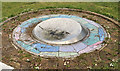
The Loughview Compass sculpture, Holywood
A sculpture, by Duncan Ross and Helen Sharp, on Jackson’s Road opposite the Old Holywood Road. Unveiled in April 2009 it’s now looking a bit forgotten/neglected.
Image: © Albert Bridge
Taken: 12 May 2012
0.16 miles
5
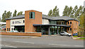
Holywood Baptist church
Holywood Baptist church on the Belfast Road. Still relatively, new the first service was on Christmas Day 2011. The architect was William Shannon http://www.williamshannon.com/projects.html.
Image: © Albert Bridge
Taken: 30 Oct 2013
0.16 miles
6
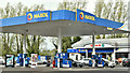
Kinnegar petrol station, Holywood (May 2018)
A Maxol petrol station and a Spar shop at 49 Belfast Road. I have no connection with the business.
Image: © Albert Bridge
Taken: 5 May 2018
0.17 miles
7
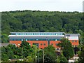
MI5 headquarters Northern Ireland
You won't find this on any OS maps, but nothing evades the all seeing Google satellite. MI5 moved to this building, located deep inside the Palace Barracks complex outside Holywood, in 2007. Close up views are impossible, this is taken from near the Kinnegar in Holywood approximately 1km away.
Image: © Rossographer
Taken: 4 Jul 2008
0.18 miles
8
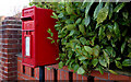
Letter box, Holywood
Post-mounted EIIR letter box on the Belfast Road.
Image: © Albert Bridge
Taken: 10 Mar 2011
0.19 miles
9
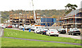
New houses, Holywood
New houses under construction at the eastern end of West Link.
Image: © Albert Bridge
Taken: 30 Oct 2013
0.19 miles
10
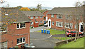
Strathearn Court, Holywood
Part of a 1980’s development of houses and apartments between the Belfast Road and the bypass http://www.geograph.org.uk/snippet/5580. The apartments were skilfully designed to resemble houses.
Image: © Albert Bridge
Taken: 30 Oct 2013
0.19 miles