IMAGES TAKEN NEAR TO
Kinnegar Avenue, HOLYWOOD, BT18 9JS
Introduction
This page details the photographs taken nearby to Kinnegar Avenue, BT18 9JS by members of the Geograph project.
The Geograph project started in 2005 with the aim of publishing, organising and preserving representative images for every square kilometre of Great Britain, Ireland and the Isle of Man.

There are currently over 7.5m images from over14,400 individuals and you can help contribute to the project by visiting https://www.geograph.org.uk
Image Map
Images are licensed for reuse under creativecommons.org/licenses/by-sa/2.0
Notes
- Clicking on the map will re-center to the selected point.
- The higher the marker number, the further away the image location is from the centre of the postcode.
Image Listing (74 Images Found)
Images are licensed for reuse under creativecommons.org/licenses/by-sa/2.0
Image
Details
Distance
1
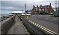
The North Down Coastal Path at Kinnegar
The start/finish of the coastal path at Kinnegar on the coastal side of Holywood, although "officially" it might start a few hundred metres along the path close to the entrance of Holywood Railway Station. From here the path extends all the way to Orlock some 16 miles away.
Behind the camera position is this road Image which leads into Belfast Harbour Estate to connect with the Greenway network at Victoria Park Image or onto the city centre - both routes much preferred by cyclists and walkers than the main city centre roads.
Image: © Rossographer
Taken: 4 Feb 2023
0.08 miles
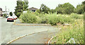
2
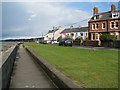
The Esplanade, Kinnegar, Holywood
The Kinnegar area of Holywood was separated from the rest of the town by the railway and, latterly, the Holywood bypass. This is part of 'The Esplanade' which has fine views out across Belfast Lough.
Image: © Rossographer
Taken: 11 Apr 2008
0.08 miles
3
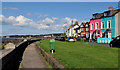
Kinnegar Road, Holywood
A street, running from Kinnegar Avenue (behind me) to The Esplanade, with uninterrupted views over Belfast Lough. Shown as Kinnegar Road on the OS street map and The Esplanade on the Google map.
Image: © Albert Bridge
Taken: 16 Aug 2011
0.09 miles
4
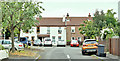
Kinnegar Court, Holywood (July 2018)
Social housing on the western side of Kinnegar Drive. The 1832/46 map shows the site, before reclamation, as the Holywood Bank, Belfast Lough.
Image: © Albert Bridge
Taken: 12 Jul 2018
0.09 miles
5
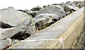
Sea defences, Holywood (January 2015)
Rock armour sea defences, along the shore of Belfast Lough, at The Esplanade, Holywood. They counter coastal erosion but not flooding Image Previously seen in Image (May 2012).
Image: © Albert Bridge
Taken: 5 Jan 2015
0.10 miles
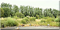
6
Development site, Kinnegar Drive, Holywood - July 2018(2)
The site looking towards the shore.
Image: © Albert Bridge
Taken: 12 Jul 2018
0.10 miles
7
Development site, Kinnegar Drive, Holywood - July 2018(1)
The site looking towards the railway (hidden behind the trees). For the record Kinnegar Drive was previously called Bryon Street.
Image: © Albert Bridge
Taken: 12 Jul 2018
0.10 miles
8
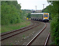
Train approaching Holywood station
Northern Ireland Railways 6 car C3K set (3011 & 3009) approaching Holywood with the 1555 Belfast Great Victoria Street to Bangor service (departs Holywood at 1615).
Image: © Rossographer
Taken: 1 Jul 2013
0.10 miles
9
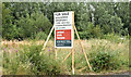
Development site, Kinnegar Drive, Holywood - July 2018(3)
The agents’ “for sale” board.
Image: © Albert Bridge
Taken: 12 Jul 2018
0.10 miles
10
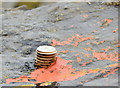
Survey mark, Holywood - January 2015(2)
A survey mark, attached to the rock armour Image, at The Esplanade.
Image: © Albert Bridge
Taken: 5 Jan 2015
0.10 miles