1
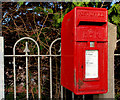
Letter box, Holywood
Post-mounted EIIR letter box, in High Street, opposite
Image
Image: © Albert Bridge
Taken: 1 Feb 2011
0.02 miles
2
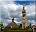
Spire of St Colmcille's, Holywood [2]
Another view of the spire of St Comcille's in Holywood (see
Image) showing the gap left between the spire and modern rebuilt church just seen to the left.
Image: © Rossographer
Taken: 20 Jun 2008
0.03 miles
3
Stanton & Staveley manhole cover, Holywood
Stanton & Staveley manhole covers are among the most common found in the streets of NI. This “Chieftain 600” is in the Spafields car park, in High Street.
Image: © Albert Bridge
Taken: 1 Mar 2011
0.03 miles
4
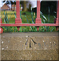
Bench Mark, Holywood
Rivet bench mark on a wall around St Comcile's church in Holywood
Image The arrow points to a small brass rivet set into the top of the wall.
The mark is 11.75 metres above MSL.
See also http://www.geograph.org.uk/search.php?i=11037856 for many other examples I have found.
Image: © Rossographer
Taken: 19 Mar 2010
0.04 miles
5
Steps and ramps, Spafields, Holywood (May 2016)
Steps and disabled-access ramps leading from the car park to the playing fields
Image The existing steps have been retained (out of picture to the right).
Image: © Albert Bridge
Taken: 17 May 2016
0.04 miles
6
Spire of St Colmcille's, Holywood [1]
The 120 foot high spire of St Comcille's (see
Image) is a prominent feature on the southern side of Holywood. This is a view from several hundred yards away.
Image: © Rossographer
Taken: 20 Jun 2008
0.04 miles
7
Memorial, St Comcille's, Holywood
The churchyard of St Comcille's contains memorial stones to many of the departed parish priests. The most elaborate is this celtic cross in memory of the Rt Reverend Monsignor O'Laverty who died on the 18th April 1906, aged 78 years.
Monsignor O'Laverty was pastor of St Comcille's (written as St Columb-kills on the memorial) for 40 years.
Image: © Rossographer
Taken: 20 Jun 2008
0.04 miles
8
Spire of St Colmcille's, Holywood [3]
A third picture of the spire of St Comcille's in Holywood (see
Image), this time from directly underneath. The spire had the following inscription dating from the original church, dedicated in 1874:
"Have mercy O Lord on the soul of Patrick Read, at whose bequest this tower was completed AD1890. The Church of St. Columba dedicated June 14th 1874"
When the spire was repaired following the fire of 1989 the following inscription was added:
"New church built and tower restored 1993 AD"
The spire still contains the original bell. However, to prevent further damage to the structure, this is now struck electronically rather than rung by hand.
Image: © Rossographer
Taken: 20 Jun 2008
0.04 miles
9
Spafield car park, Holywood
A large and free car park, at High Street, close to the town centre and here http://www.geograph.org.uk/search.php?i=44666144.
Image: © Albert Bridge
Taken: 30 Oct 2013
0.05 miles
10
St Colmcille's, Holywood
St Colmcille's RC church in Holywood, County Down. It is located at the corner of High Street and My Lady's Mile.
The original church, built of local white Scrabo and imported red Dumfries stone with a pitch pine roof, was first dedicated on Sunday 14th June 1874. The later addition of a bell tower was not completed until 1891. However, what we see today is a different structure.
The original 1874 construction was destroyed by a malicious fire (probably sectarian) in the early hours of 24th August 1989. After the fire, the 120-foot tower remained but was deemed to be structurally unsafe. It was decided, however, to restore it using some of the stone salvaged from the old church. The main church structure was beyond repair and this was replaced with a new circular structure, seen to the left of the tower. The reconstructed St Colmcille's seen here was rededicated by Bishop of Down and Connor, Dr. Patrick Walsh, on Sunday 28th May 1995.
See the parish website at http://www.parishofholywood.org/ for more information.
Image: © Rossographer
Taken: 20 Jun 2008
0.05 miles


