IMAGES TAKEN NEAR TO
Mollhead Road, HOLYWOOD, BT18 9GR
Introduction
This page details the photographs taken nearby to Mollhead Road, BT18 9GR by members of the Geograph project.
The Geograph project started in 2005 with the aim of publishing, organising and preserving representative images for every square kilometre of Great Britain, Ireland and the Isle of Man.

There are currently over 7.5m images from over14,400 individuals and you can help contribute to the project by visiting https://www.geograph.org.uk
Image Map
Images are licensed for reuse under creativecommons.org/licenses/by-sa/2.0
Notes
- Clicking on the map will re-center to the selected point.
- The higher the marker number, the further away the image location is from the centre of the postcode.
Image Listing (98 Images Found)
Images are licensed for reuse under creativecommons.org/licenses/by-sa/2.0
Image
Details
Distance
1
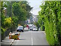
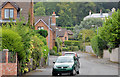
Church Road, Holywood
Looking down Church Road towards Holywood town centre from near Glenlyon park.
Image: © Rossographer
Taken: 21 May 2008
0.03 miles
2
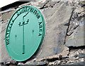
Conservation Area plaque, Holywood
A plaque, mounted on a garden wall on the Demesne Road, marking the area’s status as part of the Holywood Conservation Area http://www.planningni.gov.uk/index/news/news_policy/smt-news-3.htm.
Image: © Albert Bridge
Taken: 30 Aug 2013
0.05 miles
3
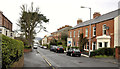
Church Road, Holywood (1)
A residential road, with views to the Co Antrim side of Belfast Lough (background), running uphill to the south east of the town centre. Lined by many Victorian terraces - some of which are listed. Riverside Terrace Image (right) is not listed but is described there as “A block of two semi-detached two-storey late-nineteenth century houses, located on Church Road near Holywood town centre. Both have been altered over the years, with replacement windows and entrance doors to front.”.
Image: © Albert Bridge
Taken: 10 Dec 2011
0.06 miles
4
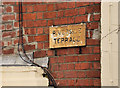
Church Road, Holywood (2)
The name sign on Riverside Terrace – on the right in Image
Image: © Albert Bridge
Taken: 10 Dec 2011
0.06 miles
5
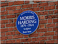
Morris Harding plaque, Holywood
A plaque on a house at Church Road, Holywood commemorating the sculptor Morris Harding http://www.ulsterhistory.co.uk/harding.htm. Much of his work is inside St Anne’s Cathedral http://www.geograph.org.uk/snippet/4769 but one small external work can be seen on Telephone House Image
Image: © Albert Bridge
Taken: 27 Apr 2012
0.06 miles
6
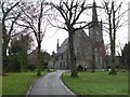
Parish Centre, Holywood
It is located beside the Church of Ireland
Image: © Kenneth Allen
Taken: 11 Dec 2009
0.07 miles
7
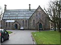
Church of SS Philip and James
It is in the Parish of Holywood
Image: © Kenneth Allen
Taken: 11 Dec 2009
0.08 miles
8
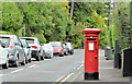
Pillar box, Holywood
EIIR pillar box (BT18 184) at the Church Road end of Church Avenue.
Image: © Albert Bridge
Taken: 30 Aug 2013
0.08 miles
9
Demesne Manor, Holywood
A cul-de-sac of modern houses on the eastern side of the Demesne Road.
Image: © Albert Bridge
Taken: 30 Aug 2013
0.09 miles
10
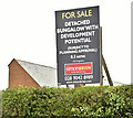
No 8B Demesne Road, Holywood - April 2018(2)
The agent’s “for sale” board.
Image: © Albert Bridge
Taken: 26 Apr 2018
0.09 miles