IMAGES TAKEN NEAR TO
My Ladys Mile, HOLYWOOD, BT18 9ER
Introduction
This page details the photographs taken nearby to My Ladys Mile, BT18 9ER by members of the Geograph project.
The Geograph project started in 2005 with the aim of publishing, organising and preserving representative images for every square kilometre of Great Britain, Ireland and the Isle of Man.

There are currently over 7.5m images from over14,400 individuals and you can help contribute to the project by visiting https://www.geograph.org.uk
Image Map
Images are licensed for reuse under creativecommons.org/licenses/by-sa/2.0
Notes
- Clicking on the map will re-center to the selected point.
- The higher the marker number, the further away the image location is from the centre of the postcode.
Image Listing (101 Images Found)
Images are licensed for reuse under creativecommons.org/licenses/by-sa/2.0
Image
Details
Distance
1
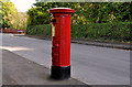
Pillar box, Holywood
EVIIR pillar box, at the corner of My Lady’s Mile and Ardlee Avenue (behind me).
Image: © Albert Bridge
Taken: 18 Sep 2011
0.08 miles
2
The Downshire Road, Holywood
See Image (February 2006). The steep Downshire Road, from the top, at the corner of the Demesne Road, looking downhill towards the Church Road and Belfast Lough. Image (July 2008) shows a view in the opposite direction.
Image: © Albert Bridge
Taken: 4 Oct 2013
0.10 miles
3
Ardlee Avenue, Holywood (1)
A street running from the Downshire Road (foreground) to My Lady’s Mile. Ardlee Terrace is on the left. See also Image
Image: © Albert Bridge
Taken: 10 Dec 2011
0.10 miles
4
Ardlee Avenue. Holywood (2)
The name sign on Ardlee Terrace – on the left in Image
Image: © Albert Bridge
Taken: 10 Dec 2011
0.11 miles
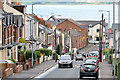
5
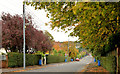
My Lady's Mile, Holywood
A suburban road running from High Street to the Demesne Road Image This view is outward from opposite the southern end of Church View Image with the autumn colours on display. The road’s name is unusual and an explanation is not easy to find. One thing which seems reasonably certain is that it has no connection with this one Image where the “Lady” in question was related to Lord Donegall. One suggestion for Holywood is that the name was originally “Our Lady’s Mile” implying a religious connection which is not unreasonable given the origin of the town’s name. Another is that the “Lady” was a relative of Sir Hugh Montgomery Image and Image who had been granted land in north Down and the Ards as part of the Plantation of Ulster.
Image: © Albert Bridge
Taken: 30 Oct 2013
0.11 miles
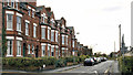
6
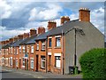
Terrace, Church View, Holywood
Terraced housing on Church View, typical of this area of Holywood.
Image: © Rossographer
Taken: 20 Jun 2008
0.12 miles
7

First conker of the year
The first conkers have just started to appear on the horse chestnuts in the past week or so.
Image: © Rossographer
Taken: 20 Jun 2008
0.13 miles
8
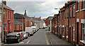
Church View, Holywood (2)
See Image (September 2011). Church View, looking down the hill, from opposite Ean Hill, towards Park Drive (the first street on the right).
Image: © Albert Bridge
Taken: 12 May 2012
0.13 miles
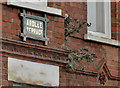
9
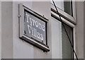
Tyrone Villas sign, Holywood
The name sign, on a terrace on the Downshire Road, between Downshire Place and Church View Image
Image: © Albert Bridge
Taken: 10 Dec 2011
0.13 miles
10
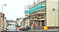
Nos 44-54 Spencer Street, Holywood (April 2018)
Social housing, with scaffolding, during renovation.
Image: © Albert Bridge
Taken: 26 Apr 2018
0.13 miles