IMAGES TAKEN NEAR TO
Church Road, HOLYWOOD, BT18 9BY
Introduction
This page details the photographs taken nearby to Church Road, BT18 9BY by members of the Geograph project.
The Geograph project started in 2005 with the aim of publishing, organising and preserving representative images for every square kilometre of Great Britain, Ireland and the Isle of Man.

There are currently over 7.5m images from over14,400 individuals and you can help contribute to the project by visiting https://www.geograph.org.uk
Image Map
Images are licensed for reuse under creativecommons.org/licenses/by-sa/2.0
Notes
- Clicking on the map will re-center to the selected point.
- The higher the marker number, the further away the image location is from the centre of the postcode.
Image Listing (94 Images Found)
Images are licensed for reuse under creativecommons.org/licenses/by-sa/2.0
Image
Details
Distance
1
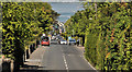
The Church Road, Holywood (3)
See Image The upper part of the Church Road, from the entrance to Glenlyon Park, looking down to the town centre and Belfast Lough (background). Image (shows a similar view on the same day (by coincidence) in May 2008). Continue to Image
Image: © Albert Bridge
Taken: 21 May 2012
0.02 miles
2
Windsor Avenue, Holywood
A short cul-de-sac on the eastern side of the Demesne Road.
Image: © Albert Bridge
Taken: 30 Aug 2013
0.03 miles
3
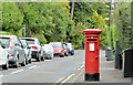
Pillar box, Holywood
EIIR pillar box (BT18 184) at the Church Road end of Church Avenue.
Image: © Albert Bridge
Taken: 30 Aug 2013
0.05 miles
4
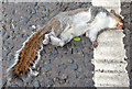
Dead squirrel, Holywood (May 2015)
A dead grey squirrel, by the side of the Church Road, close to Glenlyon http://www.geograph.org.uk/snippet/6208. Squirrels are agile when climbing trees but vulnerable crossing roads.
Image: © Albert Bridge
Taken: 12 May 2015
0.05 miles
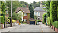
5

Glenlyon entrance, Holywood (June 2014)
The entrance to Glenlyon from the Church Road. This sign Image is on the right.
Image: © Albert Bridge
Taken: 27 Jun 2014
0.07 miles
6
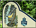
Entrance sign, Glenlyon, Holywood (June 2014)
See Image (May 2008). A detail from the same sign on the Church Road. It will be interesting to see what happens to it (and similar ones Image and Image) when North Down and Ards councils amalgamate in 2015. See also Image
Image: © Albert Bridge
Taken: 27 Jun 2014
0.08 miles
7
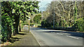
"C" road, Holywood (March 2017)
Not generally known but the Church Road, Holywood Image and Image is classified as a “C” road. This view is inward at Glenlyon.
The following is a quotation from the official “Traffic Watch” website “High Street, Holywood - Closures 7pm to 6am - 20 to 24 March [2017] High Street, Holywood (B198) will be closed to through traffic, from its junction with C303 Church Road to U8106 Downshire Road junction, to enable resurfacing works from 7pm each evening to 6am the following morning on Monday 20th, Tuesday 21st, Wednesday 22nd and Thursday 23rd March 2017 (works being completed by 6am Friday 24th March)”. See also Image
Image: © Albert Bridge
Taken: 24 Mar 2017
0.08 miles
8
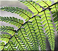
Fern, Glenlyon, Holywood (March 2017)
A backlit fern leaf on a glorious early Spring day.
Image: © Albert Bridge
Taken: 24 Mar 2017
0.09 miles
9
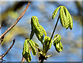
Chestnut leaves, Glenlyon, Holywood (March 2017)
A sign of Spring as the horse chestnut leaves start to unfold.
Image: © Albert Bridge
Taken: 24 Mar 2017
0.09 miles
10
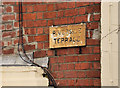
Church Road, Holywood (2)
The name sign on Riverside Terrace – on the right in Image
Image: © Albert Bridge
Taken: 10 Dec 2011
0.09 miles