IMAGES TAKEN NEAR TO
Church Avenue, HOLYWOOD, BT18 9BJ
Introduction
This page details the photographs taken nearby to Church Avenue, BT18 9BJ by members of the Geograph project.
The Geograph project started in 2005 with the aim of publishing, organising and preserving representative images for every square kilometre of Great Britain, Ireland and the Isle of Man.

There are currently over 7.5m images from over14,400 individuals and you can help contribute to the project by visiting https://www.geograph.org.uk
Image Map
Images are licensed for reuse under creativecommons.org/licenses/by-sa/2.0
Notes
- Clicking on the map will re-center to the selected point.
- The higher the marker number, the further away the image location is from the centre of the postcode.
Image Listing (97 Images Found)
Images are licensed for reuse under creativecommons.org/licenses/by-sa/2.0
Image
Details
Distance
1
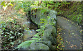
Twisel Burn and path, Holywood
The Twisel Burn, at a much lower level than this view Image in October 2013, looking upstream. The path leads to here Image and the Victoria Road.
Image: © Albert Bridge
Taken: 7 Feb 2014
0.06 miles
2
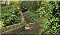
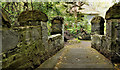
Path, Holywood
The path, from Church Avenue, along the Twisel Burn (behind the wall on the left), to the Twisel Bridge Image hidden in the background).
Image: © Albert Bridge
Taken: 27 Apr 2012
0.06 miles
3
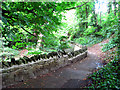
Path by Twisel Burn, Holywood
The path alongside Twisel Burn in Holywood. Looking in the direction of Twisel Bridge - Image
Image: © Rossographer
Taken: 10 Jun 2008
0.06 miles
4
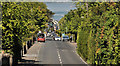
The Church Road, Holywood (3)
See Image The upper part of the Church Road, from the entrance to Glenlyon Park, looking down to the town centre and Belfast Lough (background). Image (shows a similar view on the same day (by coincidence) in May 2008). Continue to Image
Image: © Albert Bridge
Taken: 21 May 2012
0.07 miles
5
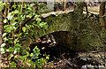
The Twisel Bridge, Holywood (2)
See Image The bridge from ground level. The Twisel Burn is flowing from left to right. Image shows the view in the opposite direction.
Image: © Albert Bridge
Taken: 27 Apr 2012
0.07 miles
6
The Twisel Bridge, Holywood (1)
The Twisel Bridge, described in Image (June 2008), seen from the steps Image from the Victoria Road. Image shows a ground-level view.
Image: © Albert Bridge
Taken: 27 Apr 2012
0.07 miles
7
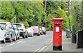
Pillar box, Holywood
EIIR pillar box (BT18 184) at the Church Road end of Church Avenue.
Image: © Albert Bridge
Taken: 30 Aug 2013
0.08 miles
8
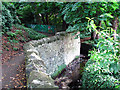
Twisel Burn, Holywood
Twisel Burn in Holywood. The wall and path were built at the same time as nearby Twisel Bridge - see Image The water level low after two months of very dry weather, the burn is prone to severe flooding. In June 1999 the river level rose some 12 feet above normal after a particularly severe flash flood, devasting nearby homes.
Image: © Rossographer
Taken: 10 Jun 2008
0.08 miles
9
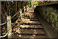
Steps, Holywood
Steps, leading from the Victoria Road (top), to the Twisel Bridge Image and the Twisel Burn.
Image: © Albert Bridge
Taken: 27 Apr 2012
0.08 miles
10
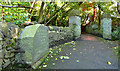
The Twisel Bridge, Holywood - February 2014
See Image (April 2012). The Twisel Bridge, looking in the opposite direction – towards the Victoria Road. The stone (left) has the inscription described in Image
Image: © Albert Bridge
Taken: 7 Feb 2014
0.08 miles