IMAGES TAKEN NEAR TO
Victoria Road, HOLYWOOD, BT18 9BG
Introduction
This page details the photographs taken nearby to Victoria Road, BT18 9BG by members of the Geograph project.
The Geograph project started in 2005 with the aim of publishing, organising and preserving representative images for every square kilometre of Great Britain, Ireland and the Isle of Man.

There are currently over 7.5m images from over14,400 individuals and you can help contribute to the project by visiting https://www.geograph.org.uk
Image Map
Images are licensed for reuse under creativecommons.org/licenses/by-sa/2.0
Notes
- Clicking on the map will re-center to the selected point.
- The higher the marker number, the further away the image location is from the centre of the postcode.
Image Listing (107 Images Found)
Images are licensed for reuse under creativecommons.org/licenses/by-sa/2.0
Image
Details
Distance
1
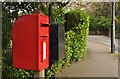
Letter box, Holywood
Post-mounted EIIR letter box (BT18 52 – officially “The Manse”) on the Victoria Road. Accompanied by a black drop box.
Image: © Albert Bridge
Taken: 2 Mar 2012
0.03 miles
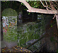
2
The Twisel Bridge, Holywood - February 2014
See Image (April 2012). The Twisel Bridge, looking in the opposite direction – towards the Victoria Road. The stone (left) has the inscription described in Image
Image: © Albert Bridge
Taken: 7 Feb 2014
0.04 miles
3
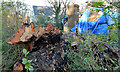
Felled tree and damaged house, Holywood
A felled tree and a damaged house beside the Victoria Road – the two might not be unconnected.
Image: © Albert Bridge
Taken: 7 Feb 2014
0.05 miles
4
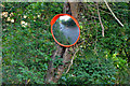
Traffic mirror, Holywood (2)
A traffic mirror on the Victoria Road – a road of many bends and concealed entrances Image
Image: © Albert Bridge
Taken: 7 Feb 2014
0.05 miles
5
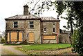
Vacant house, Holywood (1)
This vacant and boarded-up house is “Brook House”, 17 Croft Road. I was able to download the agents’ brochure which shows it occupied and looking exceptionally desirable. The brochure describes it, inter alia, as “Set well back from Croft Road on an extensive site ‘Brook House’ oozes character and has retained many of its original features including: cornice ceilings, ornate centre roses, panelled doors, high ceilings, sash windows and storm shutters”. Whatever the story it now has a “sold” sign Image
Image: © Albert Bridge
Taken: 2 Mar 2012
0.06 miles
6
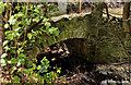
Twisel Bridge, Holywood
Bridge over the charmingly named Twisel Burn in Holywood.
Although taken on a reasonably bright summer afternoon I had to employ the flash here - the surrounding trees are so dense that most natural light is blocked out - it was so dark that street lamps alongside the bridge appear to be constantly switched on.
A stone nearby records that the bridge and it's approach were constructed in 1912 as a memorial to Richard Patterson "who for many years took an active part in every good work in Holywood".
The bridge and the connecting path alongside Twisel Burn run from Victoria Road to Church Avenue. Sadly, the whole area appears very neglected now. Despite the location in an affluent and historic area of Holywood it is abound with graffiti and litter.
Image: © Rossographer
Taken: 10 Jun 2008
0.07 miles
7
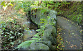
Twisel Burn and path, Holywood
The Twisel Burn, at a much lower level than this view Image in October 2013, looking upstream. The path leads to here Image and the Victoria Road.
Image: © Albert Bridge
Taken: 7 Feb 2014
0.07 miles
8
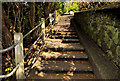
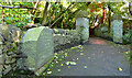
Steps, Holywood
Steps, leading from the Victoria Road (top), to the Twisel Bridge Image and the Twisel Burn.
Image: © Albert Bridge
Taken: 27 Apr 2012
0.07 miles
9
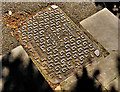
Glynwed Brickhouse "Valiant" access cover, Holywood
A Glynwed Brickhouse “Valiant” http://www.geograph.org.uk/search.php?i=30855228 access cover, on the Victoria Road, at the top of the steps to the Twisel Bridge.
Image: © Albert Bridge
Taken: 27 Apr 2012
0.07 miles
10
The Twisel Bridge, Holywood (1)
The Twisel Bridge, described in Image (June 2008), seen from the steps Image from the Victoria Road. Image shows a ground-level view.
Image: © Albert Bridge
Taken: 27 Apr 2012
0.08 miles