IMAGES TAKEN NEAR TO
Loughview Fold, High Street, HOLYWOOD, BT18 9AL
Introduction
This page details the photographs taken nearby to Loughview Fold, High Street, BT18 9AL by members of the Geograph project.
The Geograph project started in 2005 with the aim of publishing, organising and preserving representative images for every square kilometre of Great Britain, Ireland and the Isle of Man.

There are currently over 7.5m images from over14,400 individuals and you can help contribute to the project by visiting https://www.geograph.org.uk
Image Map
Images are licensed for reuse under creativecommons.org/licenses/by-sa/2.0
Notes
- Clicking on the map will re-center to the selected point.
- The higher the marker number, the further away the image location is from the centre of the postcode.
Image Listing (230 Images Found)
Images are licensed for reuse under creativecommons.org/licenses/by-sa/2.0
Image
Details
Distance
1
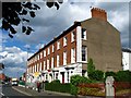
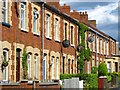
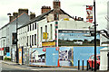
Terrace, High Street, Holywood
A nice terrace, largely unaltered, on the southern end of High Street in Holywood.
Image: © Rossographer
Taken: 20 Jun 2008
0.04 miles
2
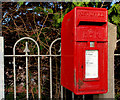
Letter box, Holywood
Post-mounted EIIR letter box, in High Street, opposite Image
Image: © Albert Bridge
Taken: 1 Feb 2011
0.04 miles
3
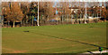
Playing fields, Holywood (2)
Part of the North Down Borough Council Spafields playing fields, between High Street and the bypass.
Image: © Albert Bridge
Taken: 1 Mar 2011
0.05 miles
4
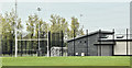
Pavilion, Spafields, Holywood (May 2016)
The recently-constructed pavilion at the Spafields playing fields.
Image: © Albert Bridge
Taken: 17 May 2016
0.05 miles
5
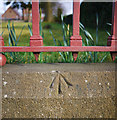
Bench Mark, Holywood
Rivet bench mark on a wall around St Comcile's church in Holywood Image The arrow points to a small brass rivet set into the top of the wall.
The mark is 11.75 metres above MSL.
See also http://www.geograph.org.uk/search.php?i=11037856 for many other examples I have found.
Image: © Rossographer
Taken: 19 Mar 2010
0.06 miles
6
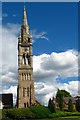
Spire of St Colmcille's, Holywood [2]
Another view of the spire of St Comcille's in Holywood (see Image) showing the gap left between the spire and modern rebuilt church just seen to the left.
Image: © Rossographer
Taken: 20 Jun 2008
0.06 miles
7
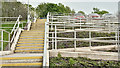
Steps and ramps, Spafields, Holywood (May 2016)
Steps and disabled-access ramps leading from the car park to the playing fields Image The existing steps have been retained (out of picture to the right).
Image: © Albert Bridge
Taken: 17 May 2016
0.06 miles
8
Terrace, Ean Hill, Holywood
A nice brick terrace on Ean Hill, just off High Street in Holywood.
Image: © Rossographer
Taken: 20 Jun 2008
0.06 miles
9
Stanton & Staveley manhole cover, Holywood
Stanton & Staveley manhole covers are among the most common found in the streets of NI. This “Chieftain 600” is in the Spafields car park, in High Street.
Image: © Albert Bridge
Taken: 1 Mar 2011
0.06 miles
10
Nos 122-124 High Street, Holywood - June 2018(2)
The view from the Belfast side. Demolition started but has now stopped.
Image: © Albert Bridge
Taken: 20 Jun 2018
0.07 miles