IMAGES TAKEN NEAR TO
Rathmoyle Park, HOLYWOOD, BT18 0DT
Introduction
This page details the photographs taken nearby to Rathmoyle Park, BT18 0DT by members of the Geograph project.
The Geograph project started in 2005 with the aim of publishing, organising and preserving representative images for every square kilometre of Great Britain, Ireland and the Isle of Man.

There are currently over 7.5m images from over14,400 individuals and you can help contribute to the project by visiting https://www.geograph.org.uk
Image Map
Images are licensed for reuse under creativecommons.org/licenses/by-sa/2.0
Notes
- Clicking on the map will re-center to the selected point.
- The higher the marker number, the further away the image location is from the centre of the postcode.
Image Listing (17 Images Found)
Images are licensed for reuse under creativecommons.org/licenses/by-sa/2.0
Image
Details
Distance
1

A cliff top section of the North Down Coastal Path
Image: © Eric Jones
Taken: 20 May 2012
0.22 miles
2
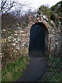
Old entrance gate, Seahill
Part of an old wall and gate near Seahill on the North Down Coastal Path towards Helen's Bay.
Image: © Rossographer
Taken: 8 Mar 2008
0.22 miles
3
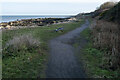
The North Down Coastal Path at Seahill
The path continuing around Seahill. Here it is a rough track which can get very muddy in wet weather. This is the view looking back towards Helen's Bay.
Image: © Rossographer
Taken: 30 Jan 2023
0.22 miles
4
![Shore near Seahill [1]](https://s2.geograph.org.uk/photos/72/06/720686_442805c5_120x120.jpg)
Shore near Seahill [1]
Looking along the North Down Coastal Path towards Helen's Bay.
Image: © Rossographer
Taken: 8 Mar 2008
0.22 miles
5
The eastern end of the beach at Rockport from the North Down Coastal Path
Image: © Eric Jones
Taken: 20 May 2012
0.23 miles
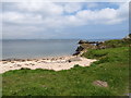
6
![Shore near Seahill [2]](https://s3.geograph.org.uk/photos/72/06/720687_d7dd1220_120x120.jpg)
Shore near Seahill [2]
The remains of a ruined building near the shoreline.
Image: © Rossographer
Taken: 8 Mar 2008
0.23 miles
7
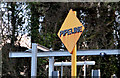
"Pipeline" sign, Seahill
A yellow diamond sign, beside the North Down coastal path, warning about the outfall from the Seahill waste water treatment works Image Previously seen in March 2008 Image
Image: © Albert Bridge
Taken: 6 Feb 2013
0.24 miles
8
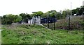
NI Water's Salthill Sewage Treatment Works
Image: © Eric Jones
Taken: 20 May 2012
0.24 miles
9

Pipeline warning sign, Seahill
The sign is at the sewage treatment works at Seahill - it points towards Belfast Lough as a warning to boats and ships as there is an undersea pipeline running several hundred yards out into the lough.
Image: © Rossographer
Taken: 8 Mar 2008
0.24 miles
10
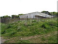
Salthill Sewage Treatment Works
This discharges into Belfast Lough.
Image: © Eric Jones
Taken: 20 May 2012
0.24 miles