IMAGES TAKEN NEAR TO
Seahill Road, HOLYWOOD, BT18 0DB
Introduction
This page details the photographs taken nearby to Seahill Road, BT18 0DB by members of the Geograph project.
The Geograph project started in 2005 with the aim of publishing, organising and preserving representative images for every square kilometre of Great Britain, Ireland and the Isle of Man.

There are currently over 7.5m images from over14,400 individuals and you can help contribute to the project by visiting https://www.geograph.org.uk
Image Map
Images are licensed for reuse under creativecommons.org/licenses/by-sa/2.0
Notes
- Clicking on the map will re-center to the selected point.
- The higher the marker number, the further away the image location is from the centre of the postcode.
Image Listing (30 Images Found)
Images are licensed for reuse under creativecommons.org/licenses/by-sa/2.0
Image
Details
Distance
1
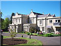
Camphill Community, Glencraig
One of the many buildings on the sprawling 100 acre site of the Camphill Community at Glencraig near Holywood. This old converted house appears to be the focal point of the site which now includes dozens of buildings. I think that the house now contains a school and is known as Amairgin. See http://glencraig.org.uk/about.htm for more information on the Gencraig Camphill Community.
Looking at some old maps of the area there was once a house known as Glencarrick on this site c1850 but I don't know if this building has any connection to that.
Image: © Rossographer
Taken: 8 May 2010
0.02 miles
2
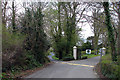
Rockport Road, Seahill
The Rockport Road with the gates to Rockport School ahead.
Image: © Rossographer
Taken: 3 Apr 2008
0.12 miles
3
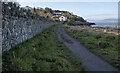
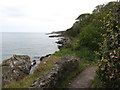
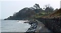
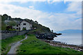
The North Down Coastal Path at Seahill
The path continuing around Seahill towards Craigavad. The short smooth section at Rockport Image again gives way to a rough uneven path here.
Image: © Rossographer
Taken: 30 Jan 2023
0.13 miles
4
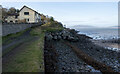
The North Down Coastal Path at Seahill
The path continuing around Seahill towards Craigavad. At this point the path rises up on a man-made section around the rocky coastline - note the rock armour placed to protect the area. It also becomes very narrow in places.
Image: © Rossographer
Taken: 30 Jan 2023
0.14 miles
5
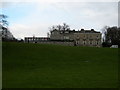
Rockport School, Seahill
Rockport School http://www.rockportschool.com/ as viewed from the North Down Coastal Path.
Image: © Rossographer
Taken: 8 Mar 2008
0.15 miles
6
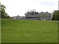
Rockport School, Craigavad
Rockport School is an independent Junior and Senior School, based on public school lines. The only school of its kind in Ulster, it was established in 1906 by Geoffrey Bing.
Image: © Eric Jones
Taken: 20 May 2012
0.15 miles
7
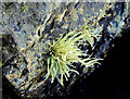
Lichen, Craigavad (2)
There were several examples of this lichen growing on the rocks beside the North Down coastal path. This was the most accessible.
Image: © Albert Bridge
Taken: 2 Oct 2012
0.16 miles
8
View eastwards along the North Down Coastal Path
The coast here is very rocky. Grey Point can be seen in the far distance.
Image: © Eric Jones
Taken: 20 May 2012
0.16 miles
10
A sea view
One of the large and expensive houses in a prime location on the so-called "Gold Coast" near Helen's Bay. The North Down Coastal Path in the foreground and a glimpse of the Belfast Hills in the distance.
Image: © Robert Ashby
Taken: 30 Apr 2014
0.16 miles