IMAGES TAKEN NEAR TO
The Orchard, HOLYWOOD, BT18 0BD
Introduction
This page details the photographs taken nearby to The Orchard, BT18 0BD by members of the Geograph project.
The Geograph project started in 2005 with the aim of publishing, organising and preserving representative images for every square kilometre of Great Britain, Ireland and the Isle of Man.

There are currently over 7.5m images from over14,400 individuals and you can help contribute to the project by visiting https://www.geograph.org.uk
Image Map
Images are licensed for reuse under creativecommons.org/licenses/by-sa/2.0
Notes
- Clicking on the map will re-center to the selected point.
- The higher the marker number, the further away the image location is from the centre of the postcode.
Image Listing (39 Images Found)
Images are licensed for reuse under creativecommons.org/licenses/by-sa/2.0
Image
Details
Distance
1
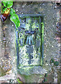
Flush Bracket, Holywood
Flush bracket located on the railway bridge on Farmhill Road, Holywood Image Somewhat inexplicably, the bracket is on the north-eastern side of the eastern wall of the bridge - i.e. on the far side of the road directly overhanging the railway. To access the bracket it would have been necessary to plant a long ladder on the railway below or precariously hang over the edge - which is what I had to do to get the photograph.
The number on the bracket is OSBM 3450.
The mark is 30.65 metres above MSL.
A flush bracket is a type of bench mark set onto the face of a building. See also http://www.geograph.org.uk/search.php?i=11037856 for many other examples I have found.
Image: © Rossographer
Taken: 21 Jul 2010
0.09 miles
2
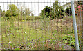
Vacant site, Marino, Holywood
The site of a now-demolished house, at the Bangor Road end of the Farmhill Road Image
Image: © Albert Bridge
Taken: 2 May 2013
0.09 miles
3
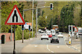
"End of dual carriageway" sign, Marino, Holywood
An “end of dual carriageway” sign, at the Whinney Hill junction, on this dual carriageway Image The road becomes four lanes until Ballyrobert where the dual carriageway resumes. Note also the overhead traffic lights.
Image: © Albert Bridge
Taken: 2 May 2013
0.10 miles
4
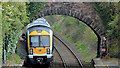
Train and bridge, Marino, Holywood
There are road overbridges at both ends of Marino station making railway photography easy. C3K set 3002 is passing under the Farmhill Road Image with the 10.45 Portadown - Bangor.
Image: © Albert Bridge
Taken: 2 May 2013
0.10 miles
5
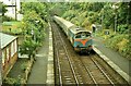
Marino station
See Image In 1983 Marino station was a particularly unkempt place. NIR was in another of its periods of shortage of rolling stock and (as seen here) used locomotives and coaches, acquired for the Dublin “Enterprise” serviceImage on stopping suburban trains. This is the 10.00 Bangor – Portadown.
Image: © Albert Bridge
Taken: 27 Aug 1983
0.10 miles
6
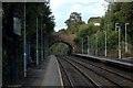
A railway bridge
Old stone railway bridge at the Bangor end of Marino station.
Image: © Wilson Adams
Taken: 23 Sep 2007
0.11 miles
7
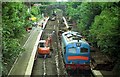
Excavations at Marino station
The line around Marino was subject to occasional flooding. A Civil Engineer’s Dept train is on the down line while the up (to Belfast) line has been lifted and is being excavated.
Image: © Albert Bridge
Taken: 22 Sep 1990
0.11 miles
8
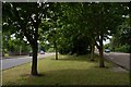
The Bangor - Belfast road at Marino
This is the Bangor – Belfast road at Marino, immediately after the start of the dual carriageway. The Belfast-bound carriageway (left) was added alongside the old road which now forms the Bangor-bound carriageway. The mature trees enhance the road considerably. Whinney Hill is behind the photographer (to the left).
Image: © Albert Bridge
Taken: 4 Jun 2007
0.11 miles
9

Bus stop and shelter, Marino, Holywood
Bus stop and shelter, on the inwards side of Whinney Hill, beside the Belfast-bound lanes of this dual carriageway Image Served by the Ulsterbus Bangor – Belfast service.
Image: © Albert Bridge
Taken: 2 May 2013
0.12 miles
10
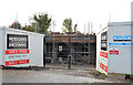
New houses, Cultra
Two new houses under construction, at Cultra Avenue, close to the railway bridge. This photograph appears as a matter of geographical and historical record only. I have no connection with any of the parties involved in the development.
Image: © Albert Bridge
Taken: 2 Nov 2013
0.12 miles