IMAGES TAKEN NEAR TO
Redwood Grove, BELFAST, BT17 9RN
Introduction
This page details the photographs taken nearby to Redwood Grove, BT17 9RN by members of the Geograph project.
The Geograph project started in 2005 with the aim of publishing, organising and preserving representative images for every square kilometre of Great Britain, Ireland and the Isle of Man.

There are currently over 7.5m images from over14,400 individuals and you can help contribute to the project by visiting https://www.geograph.org.uk
Image Map
Images are licensed for reuse under creativecommons.org/licenses/by-sa/2.0
Notes
- Clicking on the map will re-center to the selected point.
- The higher the marker number, the further away the image location is from the centre of the postcode.
Image Listing (61 Images Found)
Images are licensed for reuse under creativecommons.org/licenses/by-sa/2.0
Image
Details
Distance
1
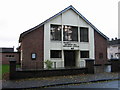
Seymour Hill Methodist Church
Situated in a large modern housing estate.
Image: © Brian Shaw
Taken: 24 Nov 2005
0.05 miles
2
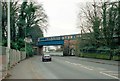
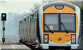
Railway Bridge
An unidentified train crossing Mc Master's railway bridge approaching Derriaghy station which is to the left of the photo. The bridge was raised and widened in the late 1950's/60's to allow double-deck buses to pass under, only the righthand arch and abutment remain of the original bridge, the girder section and abutment to the leftof the photo are new.
Image: © Wilson Adams
Taken: 18 Jan 2003
0.05 miles
3
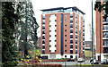
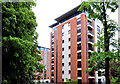
The "Redwoods" apartments, Derriaghy
See Image (April 2010) and Image (May 2011). Work on the Redwoods development, off Kingsway, stopped following the insolvency of the developer. There is a controversial plan to use part of the development as social housing. This photograph appears as a matter of geographical and historical record only and does not express any opinion about the proposal.
Image: © Albert Bridge
Taken: 24 Nov 2012
0.09 miles
4
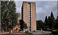
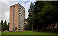
Riverdale House, Dunmurry (1)
Riverdale House is one of three identical 15-storey blocks in the Conway estate at Dunmurry/Derriaghy. Similar to Image and Image and probably built around the same time, by the Northern Ireland Housing Trust. This view, of the southern side, is from Glenwood Row.
Image: © Albert Bridge
Taken: 24 Aug 2011
0.11 miles
5
Ferndale House, Dunmurry
Ferndale House is one of three identical 15-storey blocks in the Conway estate at Dunmurry/Derriaghy. Close to Image (out of picture to the left), now surrounded by mature trees, this view is from beside the Ballybog Road.
Image: © Albert Bridge
Taken: 24 Aug 2011
0.11 miles
6
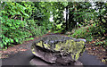
Path, Aberdelghy Wood, Derriaghy (1)
The northern end of the path, at the back of Derriaghy stationImage, is blocked by this boulder.
Image: © Albert Bridge
Taken: 28 May 2011
0.11 miles
7
Path, Aberdelghy Wood, Derriaghy
The end of the path, at Conway Lane.
Image: © Albert Bridge
Taken: 28 May 2011
0.11 miles
8
Apartments, Derriaghy (2)
See Image The same apartments, from a different viewpoint in Conway Lane.
Image: © Albert Bridge
Taken: 28 May 2011
0.12 miles
9
Signal, Derriaghy station
A colour light signal, at the Lisburn end of the up platform at Derriaghy station, displaying a green (line clear) aspect on the approach of the 10.57 Bangor – Portadown.
Image: © Albert Bridge
Taken: 24 Nov 2012
0.12 miles
10
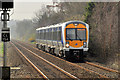
Train, Derriaghy (2012-1)
A C3K set (3008) approaching Derriaghy station with the 11.15 Portadown - Bangor. The last of the lingering mist can be seen in the background, towards Lambeg.
Image: © Albert Bridge
Taken: 23 Mar 2012
0.13 miles