IMAGES TAKEN NEAR TO
The Steadings, BELFAST, BT17 9ND
Introduction
This page details the photographs taken nearby to The Steadings, BT17 9ND by members of the Geograph project.
The Geograph project started in 2005 with the aim of publishing, organising and preserving representative images for every square kilometre of Great Britain, Ireland and the Isle of Man.

There are currently over 7.5m images from over14,400 individuals and you can help contribute to the project by visiting https://www.geograph.org.uk
Image Map
Images are licensed for reuse under creativecommons.org/licenses/by-sa/2.0
Notes
- Clicking on the map will re-center to the selected point.
- The higher the marker number, the further away the image location is from the centre of the postcode.
Image Listing (67 Images Found)
Images are licensed for reuse under creativecommons.org/licenses/by-sa/2.0
Image
Details
Distance
1
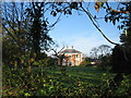
Ballyowan House
Just up the road from Gardners Loan Ends.
Image: © Brian Shaw
Taken: 21 Nov 2005
0.11 miles
3
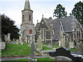
St Patrick's Drumbeg
The (C of I) Parish Church of Drumbeg. The tower dates from 1798, while the spire of 1831 replaced one that was blown down. The rest of the church dates from 1870
Image: © Brian Shaw
Taken: 24 Sep 2005
0.11 miles
4
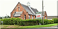
Former church hall, Drumbeg, Dunmurry (September 2018)
See Image Now with a “sold” sign.
Image: © Albert Bridge
Taken: 7 Sep 2018
0.15 miles
5
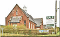
Former church hall, Drumbeg, Dunmurry (April 2018)
The former Drumbeg church hall, 162 Ballyskeagh Road, now offered for sale. The agents’ description includes “Rarely does an opportunity arise such as this to acquire such a unique building with planning permission to convert into a 'Grand Design' family home. Set on a circa 0.3 acres and currently extended to approximately 2,600 sqft the hall has full planning permsission [sic] for the conversion (change of use) to a residential dwelling. The hall has been used for a variety of purposes, such as personal fitness, charity functions and community events. The renowned 'Coogan and Co Architects' have secured planning to convert the Hall into a stunning 4 bedroom detached home The hall also has planning approval for refurbishing and extending to a larger hall, which will suit a commercial project such as offices, coffee shop etc”.
The following planning permissions apply (9 November 2017) “LA05/2017/0080/F Proposed conversion of existing church hall (change of use) to dwelling including partial demolition, refurbishment and extension with associated car parking and landscaping 162 Ballyskeagh Road Drumbeg” and (20 October 2017) “LA05/2016/1187/F Partial demolition, refurbishment and extension of 162 Ballyskeagh Road with associated car parking and landscaping (Additional information) 162 Ballyskeagh Road Drumbeg”. Continue to Image
I have no connection with the property or the sale. I cannot enter into correspondence.
Image: © Albert Bridge
Taken: 7 Apr 2018
0.15 miles
6
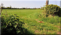
Hedge and field, Drumbeg
A field, on the southern side of the Ballyskeagh Road, seen through a gateless gap in the hedge.
Image: © Albert Bridge
Taken: 29 Apr 2011
0.16 miles
7
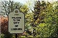
Welcome to Lisburn
One of the standard “Welcome to Lisburn” signs close to St Patrick’s Church Image Lisburn, Newry, Stirling, Preston and Newport achieved city status in 2002 . . . . . resulting in the replacement of quite a few road signs.
Image: © Albert Bridge
Taken: 5 May 2008
0.17 miles
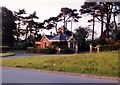
8
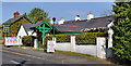
Robert Stewart's, Drumbeg (1)
A bar/restaurant, on the Ballyskeagh Road, with an interesting history http://www.bobstewarts.co.uk/about.html. Image are on the left.
Image shows the sign.
Image: © Albert Bridge
Taken: 29 Apr 2011
0.17 miles
9
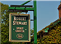
Robert Stewart's, Drumbeg (2)
The sign outside Robert Stewart’s Image
Image: © Albert Bridge
Taken: 29 Apr 2011
0.17 miles
10
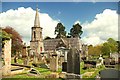
St Patrick's parish church, Drumbeg
Image: © Albert Bridge
Taken: 1 May 2009
0.17 miles