IMAGES TAKEN NEAR TO
Glenburn Road South, BELFAST, BT17 9JP
Introduction
This page details the photographs taken nearby to Glenburn Road South, BT17 9JP by members of the Geograph project.
The Geograph project started in 2005 with the aim of publishing, organising and preserving representative images for every square kilometre of Great Britain, Ireland and the Isle of Man.

There are currently over 7.5m images from over14,400 individuals and you can help contribute to the project by visiting https://www.geograph.org.uk
Image Map
Images are licensed for reuse under creativecommons.org/licenses/by-sa/2.0
Notes
- Clicking on the map will re-center to the selected point.
- The higher the marker number, the further away the image location is from the centre of the postcode.
Image Listing (70 Images Found)
Images are licensed for reuse under creativecommons.org/licenses/by-sa/2.0
Image
Details
Distance
1
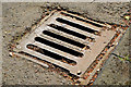
Dudley & Dowell grating cover, Dunmurry
See Image and Image A Dudley & Dowell Limited grating cover on the Glenburn Road South Image The inscription with the foundry’s name and address (Cradley Heath, Staffs) has lasted well thanks to the road being a cul-de-sac with minimal traffic.
Image: © Albert Bridge
Taken: 19 Apr 2014
0.10 miles
2
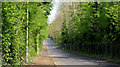
The Glenburn Road South, Dunmurry
A cul-de-sac running south from the Glenburn Road (background). It now serves only a waste water treatment works and a bible college. The M1 is hidden by the trees on the right.
Image: © Albert Bridge
Taken: 19 Apr 2014
0.12 miles
3
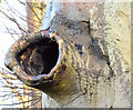
Tree canker, Dunmurry (January 2015)
A prominent tree canker beside this path Image in Dixon Park.
Image: © Albert Bridge
Taken: 17 Jan 2015
0.14 miles
4
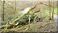
Fallen tree, Dixon Park, Dunmurry (January 2015)
Now moved, this seems to have been a victim of the very strong winds earlier in the week.
Image: © Albert Bridge
Taken: 17 Jan 2015
0.15 miles
5
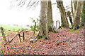
Trees and leaves, Dixon Park, Dunmurry (January 2015)
Trees and mulching leaves at the north western end of the park. The field lies between the park and Dunmurry Lane. There were a few flurries of snow at the time of the photograph.
Image: © Albert Bridge
Taken: 17 Jan 2015
0.15 miles
6
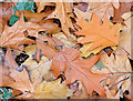
Autumn Leaves, Dunmurry (October 2014)
Autumn leaves (mainly oak) under the trees beside the Glenburn Road.
Image: © Albert Bridge
Taken: 31 Oct 2014
0.15 miles
7

The M1 near Dunmurry (1980)
See Image The same view in 1980 when traffic was much lighter and before the building of the bus lane. The current (Sunday) traffic level can be seen in Image Image shows a busier view in July 2013 after the installation of a crash barrier.
Image: © Albert Bridge
Taken: 25 May 1980
0.16 miles
8
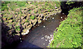
The Glen Burn, Dunmurry
The reinforced bank of the Glen Burn (now known as the Glen River), looking upstream towards Kingsway Image, from the bridge on the Glenburn Road.
Image: © Albert Bridge
Taken: 19 Apr 2014
0.18 miles
9
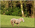
Pony, Dunmurry (January 2015)
A pony in another (sunnier) part of this field Image
Image: © Albert Bridge
Taken: 17 Jan 2015
0.19 miles
10
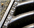
"City of Leeds" grating cover, Dunmurry (2)
See Image This legible “City of Leeds” inscription is on another cover, further south, near the bend in the Glenburn Road.
Image: © Albert Bridge
Taken: 19 Apr 2014
0.20 miles