IMAGES TAKEN NEAR TO
Mosside Road, BELFAST, BT17 9HH
Introduction
This page details the photographs taken nearby to Mosside Road, BT17 9HH by members of the Geograph project.
The Geograph project started in 2005 with the aim of publishing, organising and preserving representative images for every square kilometre of Great Britain, Ireland and the Isle of Man.

There are currently over 7.5m images from over14,400 individuals and you can help contribute to the project by visiting https://www.geograph.org.uk
Image Map
Images are licensed for reuse under creativecommons.org/licenses/by-sa/2.0
Notes
- Clicking on the map will re-center to the selected point.
- The higher the marker number, the further away the image location is from the centre of the postcode.
Image Listing (14 Images Found)
Images are licensed for reuse under creativecommons.org/licenses/by-sa/2.0
Image
Details
Distance
1
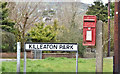
Postbox BT17 409, Derriaghy (April 2016)
Post-mounted EIIR postbox (BT17 409) at the corner of the Mosside Road and Killeaton Park.
Image: © Albert Bridge
Taken: 14 Apr 2016
0.12 miles
2
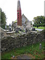
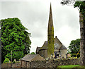
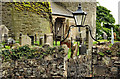
Christ Church, Derriaghy (C of I)
The Church was built in 1871 and consecrated in 1872. It is said that the Virginia Creeper on the tower is almost as old as the Church!
Image: © Brian Shaw
Taken: 28 Sep 2005
0.12 miles
3
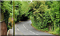
The McKinstry Road, Lambeg (1)
The McKinstry Road connects Queensway roundabout, between Lambeg and Derriaghy, with the Dunmurry bypass (background) at the Wilmar Road Image Continue to Image
Image: © Albert Bridge
Taken: 26 Oct 2010
0.15 miles
4
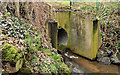
Culvert, Derriaghy
A culvert, taking what I think is the Derryaghy River Image, under The Cutts.
Image: © Albert Bridge
Taken: 7 Jan 2012
0.17 miles
5
Christ Church (Church of Ireland), Derriaghy (1)
A church, on the Derriaghy Road, the foundation stone of which was laid by William Charley Image on 24 July 1871 with completion (to a design by Welland and Gillespie) and consecration in 1872. The site was once that of an eleventh century Benedictine Priory of St Andrew. Rural in appearance but now surrounded by houses. Last seen in Image (September 2005). Image shows the tower.
Image: © Albert Bridge
Taken: 12 Jun 2012
0.18 miles
6
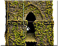
Christ Church (Church of Ireland), Derraighy (2)
See Image The tower with a lightning conductor and a coating of Virginia creeper. Image shows the entrance on the Derriaghy Road.
Image: © Albert Bridge
Taken: 12 Jun 2012
0.18 miles
7
The Derriaghy Road, Derriaghy
A small part (near Christ Church Image) of a long road running from a crossroads at The Cutts/the McKinstry Road Image towards Ballymacash, Lisburn.
Image: © Albert Bridge
Taken: 12 Jun 2012
0.19 miles
8
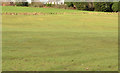
Fields, Derriaghy (2)
Fields at the northern end of the Killeaton Amenity Area.
Image: © Albert Bridge
Taken: 16 Feb 2013
0.20 miles
9
Christ Church (Church of Ireland), Derriaghy (3)
See Image The entrance, from the Derriaghy Road, to the church and graveyard.
Image: © Albert Bridge
Taken: 12 Jun 2012
0.20 miles
10
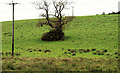
Tree near Lambeg
A solitary tree in a field, between the McKinstry and Wilmar Roads Image, in what might be termed the “green belt” between Belfast and Lisburn.
Image: © Albert Bridge
Taken: 26 Oct 2010
0.21 miles