IMAGES TAKEN NEAR TO
Kingsway, BELFAST, BT17 9EP
Introduction
This page details the photographs taken nearby to Kingsway, BT17 9EP by members of the Geograph project.
The Geograph project started in 2005 with the aim of publishing, organising and preserving representative images for every square kilometre of Great Britain, Ireland and the Isle of Man.

There are currently over 7.5m images from over14,400 individuals and you can help contribute to the project by visiting https://www.geograph.org.uk
Image Map
Images are licensed for reuse under creativecommons.org/licenses/by-sa/2.0
Notes
- Clicking on the map will re-center to the selected point.
- The higher the marker number, the further away the image location is from the centre of the postcode.
Image Listing (65 Images Found)
Images are licensed for reuse under creativecommons.org/licenses/by-sa/2.0
Image
Details
Distance
1

Vacant house, Dunmurry
Vacant, boarded-up and hidden behind several years of garden growth, this house is on the western side of Kingsway Image, at Seymour Hill. It looks like another victim of the recession.
Image: © Albert Bridge
Taken: 24 Aug 2011
0.01 miles
2
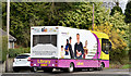
Mobile library, Seymour Hill, Dunmurry (April 2016)
A Libraries NI Iveco mobile library at Kingsway.
Image: © Albert Bridge
Taken: 14 Apr 2016
0.03 miles
3
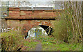
Railway underbridge, Derriaghy
A sandstone bridge carrying the Belfast – Portadown/Dublin railway across a track on the western side of Kingsway.
Image: © Albert Bridge
Taken: 12 Apr 2014
0.08 miles
4
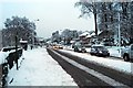
Kingsway, Seymour Hill
Kingsway, looking towards Lisburn
Image: © Wilson Adams
Taken: 4 Jan 2008
0.08 miles
5
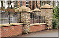
Ornamental fence, Derriaghy
Ornamental fence with stone-clad posts, at the entrance to the Redwoods development, Kingsway. These apartments Image are in the background.
Image: © Albert Bridge
Taken: 7 Jan 2012
0.09 miles
6
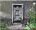
Flush Bracket, Derriaghy
Flush bracket on the bottom right hand side of the pedestrian tunnel under the railway bridge at Derriaghy on the Belfast to Lisburn Road Image It was caked in mud and almost invisible so I had to give it a good clean.
The number on the bracket is OSNIBM 3094.
The mark is 28.88 metres above MSL.
A flush bracket is a type of bench mark set onto the face of a building. See also http://www.geograph.org.uk/search.php?i=11037856 for many other examples I have found.
Image: © Rossographer
Taken: 28 Apr 2010
0.09 miles
7
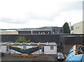
Mountupet UK Aluminium Factory, Dunmurray
Image: © Eric Jones
Taken: 28 Jul 2015
0.09 miles
8
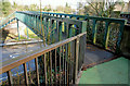
Footbridge, Derriaghy station
A footbridge, from the end of the down (Belfast-bound) platform, across Kingsway/Queensway, to the nearby industrial estate. If my memory is correct it was built around the time of the opening of the DeLorean factory.
Image: © Albert Bridge
Taken: 7 Apr 2010
0.09 miles
9
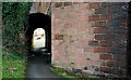
Railway bridge, Derriaghy station
The footpath, on the Lisburn – Belfast road at Derriaghy station Image, passes under the railway by means of this bridge. The road bridge is out of picture to the right. The view is towards Dunmurry and Belfast.
Image: © Albert Bridge
Taken: 7 Apr 2010
0.09 miles
10
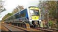
Train, Derriaghy station (2)
See Image The 13.30 Bangor – Portadown crossing the Belfast (right) – Lisburn road on the approach to Derriaghy station. Continue to Image
Image: © Albert Bridge
Taken: 26 Mar 2009
0.09 miles