IMAGES TAKEN NEAR TO
Beattie Park South, BELFAST, BT17 9BD
Introduction
This page details the photographs taken nearby to Beattie Park South, BT17 9BD by members of the Geograph project.
The Geograph project started in 2005 with the aim of publishing, organising and preserving representative images for every square kilometre of Great Britain, Ireland and the Isle of Man.

There are currently over 7.5m images from over14,400 individuals and you can help contribute to the project by visiting https://www.geograph.org.uk
Image Map
Images are licensed for reuse under creativecommons.org/licenses/by-sa/2.0
Notes
- Clicking on the map will re-center to the selected point.
- The higher the marker number, the further away the image location is from the centre of the postcode.
Image Listing (93 Images Found)
Images are licensed for reuse under creativecommons.org/licenses/by-sa/2.0
Image
Details
Distance
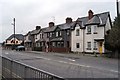
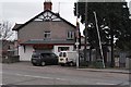
1
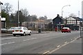
Kingsway, Dunmurry
This image was made from the Seymour Hill end of Kingsway. Between the litter bin and bus shelter this was once a road that led up to Meetinghouse Level Crossing, downgraded to a pedestrian crossing in 1959, this leads to Ashley Park on the other side of the railway line. Behind the bus shelter there once stood a row of old houses converted to shops. These were demolished around 2002. Two of the original houses are still in place beside the Dunmurry Inn.
These were demolished later. The old shops where replaced by a modern row of shops and apartments above them.
Image: © Wilson Adams
Taken: 13 Apr 2003
0.02 miles
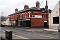
2
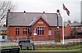
Stevesons National School EST: 1898
This old school building is now used as a Youth Centre.
Image: © Wilson Adams
Taken: 11 Mar 2007
0.02 miles
3
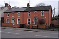
Roselea Cottages
The road sign reads Dunmurry Lane, which is incorrect. The correct name is Lower Dunmury Lane, which eventually leads to the Malone Rd.
Image: © Wilson Adams
Taken: 11 Mar 2007
0.02 miles
4
Cloncolmec
Colncolmec, Lower Dunmury Lane, which eventually leads to the Malone Rd.
Image: © Wilson Adams
Taken: 11 Mar 2007
0.02 miles
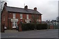
5
Paragon Terrace, Dunmurry
A row of terrace houses approaching the Crossroads from Belfast.
Image: © Wilson Adams
Taken: 11 Mar 2007
0.02 miles
6
Kingsway Kitchens, Upper Dunmurry Lane
How things have changed, Kingsway Kitchens, was previously a Green Grocers shop, and at the other end of the building, there was a confectionery shop. In between the two shops, was Browns the local Dentist.
Image: © Wilson Adams
Taken: 11 Mar 2007
0.02 miles
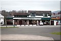
7
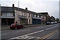
Kingsway, Dunmurry
The south end of Kingsway, (Dunmurry) looking towards Seymour Hill.
Another row of old houses converted into shops etc. I think it will be only a matter of time before this row of old shops will be knocked down and rebuilt.
Image: © Wilson Adams
Taken: 11 Mar 2007
0.02 miles
8
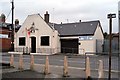
Dunmurry Orange Hall and Credit Union
Located at Upper Dunmurry Lane to the crossroads at Kingsway. The Credit Union building was constructed around 2004. Previously this area was waste ground.
Image: © Wilson Adams
Taken: 11 Mar 2007
0.02 miles
9
Dunmurry Post Office
Located at the crossroads of Kingsway and Upper/Lower Dunmurry Lane
Image: © Wilson Adams
Taken: 11 Mar 2007
0.02 miles
10
Elwoods Funeral Directors, Kingsway
Located near to the crossroads at Kingsway. The Funeral Directors used to be a Esso (Pratts) petrol station, also owned by Elwood. The garage where the cars where repaired is on the lefthand side of the building. At one time Dunmurry had three petrol stations. One on the approach from Seymour Hill, this one in the photo and the other one was located across the road from the police station. That one is the only one that remains in Dunmurry.
Image: © Wilson Adams
Taken: 11 Mar 2007
0.02 miles