IMAGES TAKEN NEAR TO
Glenburn Road, BELFAST, BT17 9BB
Introduction
This page details the photographs taken nearby to Glenburn Road, BT17 9BB by members of the Geograph project.
The Geograph project started in 2005 with the aim of publishing, organising and preserving representative images for every square kilometre of Great Britain, Ireland and the Isle of Man.

There are currently over 7.5m images from over14,400 individuals and you can help contribute to the project by visiting https://www.geograph.org.uk
Image Map
Images are licensed for reuse under creativecommons.org/licenses/by-sa/2.0
Notes
- Clicking on the map will re-center to the selected point.
- The higher the marker number, the further away the image location is from the centre of the postcode.
Image Listing (100 Images Found)
Images are licensed for reuse under creativecommons.org/licenses/by-sa/2.0
Image
Details
Distance
1
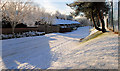
The Glenburn Road South, Dunmurry
The snow-covered area, between the Glenburn Road South and the Fullerton Park playing fields (right), close to the Glenburn Road Image
Image: © Albert Bridge
Taken: 7 Dec 2010
0.04 miles
2
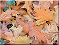
Autumn Leaves, Dunmurry (October 2014)
Autumn leaves (mainly oak) under the trees beside the Glenburn Road.
Image: © Albert Bridge
Taken: 31 Oct 2014
0.04 miles
3
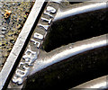
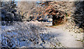
"City of Leeds" grating cover, Dunmurry (2)
See Image This legible “City of Leeds” inscription is on another cover, further south, near the bend in the Glenburn Road.
Image: © Albert Bridge
Taken: 19 Apr 2014
0.05 miles
4
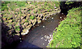
The Glen Burn, Dunmurry
The reinforced bank of the Glen Burn (now known as the Glen River), looking upstream towards Kingsway Image, from the bridge on the Glenburn Road.
Image: © Albert Bridge
Taken: 19 Apr 2014
0.05 miles
5
Jubilee Park, Dunmurry
A wooded area, along the bank of the Glen River Image, running from Kingsway to the Fullerton Park playing fields on the Glenburn Road. Covered today by snow – deeper than it looks in the photograph. Downstream from here Image
Image: © Albert Bridge
Taken: 7 Dec 2010
0.06 miles
6
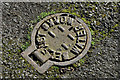
Belfast Water Works stop valve cover, Dunmurry (April 2017)
A Belfast Water Works stop valve cover close to the Glenburn Road. There is also a BWW fire hydrant cover just out of picture to the right.
Image: © Albert Bridge
Taken: 2 Apr 2017
0.07 miles
7
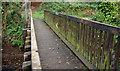
Footbridge, Dunmurry (2)
Image: © Albert Bridge
Taken: 28 Oct 2009
0.08 miles
8
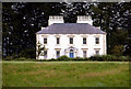
Seymour Hill House
Seymour Hill House, better known as Charley's House, or the White House as photographed in 1979.
For more info, see link.
http://www.lisburn.com/books/dunmurry-changing/dunmurry-1.html
Image: © Wilson Adams
Taken: Unknown
0.08 miles
9
Kingsway Kitchens, Upper Dunmurry Lane
How things have changed, Kingsway Kitchens, was previously a Green Grocers shop, and at the other end of the building, there was a confectionery shop. In between the two shops, was Browns the local Dentist.
Image: © Wilson Adams
Taken: 11 Mar 2007
0.08 miles
10
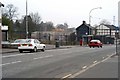
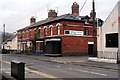
Kingsway, Dunmurry
This image was made from the Seymour Hill end of Kingsway. Between the litter bin and bus shelter this was once a road that led up to Meetinghouse Level Crossing, downgraded to a pedestrian crossing in 1959, this leads to Ashley Park on the other side of the railway line. Behind the bus shelter there once stood a row of old houses converted to shops. These were demolished around 2002. Two of the original houses are still in place beside the Dunmurry Inn.
These were demolished later. The old shops where replaced by a modern row of shops and apartments above them.
Image: © Wilson Adams
Taken: 13 Apr 2003
0.08 miles