IMAGES TAKEN NEAR TO
Mourneview Court, BELFAST, BT17 0YY
Introduction
This page details the photographs taken nearby to Mourneview Court, BT17 0YY by members of the Geograph project.
The Geograph project started in 2005 with the aim of publishing, organising and preserving representative images for every square kilometre of Great Britain, Ireland and the Isle of Man.

There are currently over 7.5m images from over14,400 individuals and you can help contribute to the project by visiting https://www.geograph.org.uk
Image Map
Images are licensed for reuse under creativecommons.org/licenses/by-sa/2.0
Notes
- Clicking on the map will re-center to the selected point.
- The higher the marker number, the further away the image location is from the centre of the postcode.
Image Listing (8 Images Found)
Images are licensed for reuse under creativecommons.org/licenses/by-sa/2.0
Image
Details
Distance
1
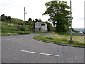
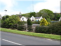
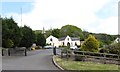
The junction of Hannahstown Hill with the B38 (Upper Springfield Road)
Image: © Eric Jones
Taken: 19 May 2012
0.04 miles
2
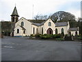
St. Joseph's Hannahstown
The leftmost nave of this Catholic Church was built in 1826. The other two were added in 1998. It's lovely inside, with the three naves pointing towards the altar.
Image: © Brian Shaw
Taken: 19 Dec 2005
0.08 miles
3
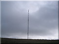
Black Mountain Transmitter Mast.
Situated at Hannahstown, West Belfast.
Image: © Peter Lyons
Taken: Unknown
0.08 miles
4
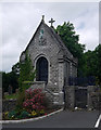
Mausoleum, Hannahstown
The Hamill mausoleum at St Joseph's RC church, Hannahstown Image
Worship began in this area around land consecrated by a Fr Hugh O’Donnell in 1797. Land here was donated by a wealthy Catholic landowner called John Hamill - he originally donated one acre of land to be used as a cemetery; his wife Hannah later donated money for a small schoolhouse which was also used as the church (it is likely that the area became known as "Hannah's Town" as a result of this).
Image: © Rossographer
Taken: 7 Jul 2010
0.18 miles
5
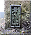
Flush Bracket, Hannahstown
Flush bracket located on the bottom of the stone nave at St Joseph's RC church, Hannahstown Image
The number on the bracket is OSNIBM 1022.
The mark is 203.60 metres above MSL.
A flush bracket is a type of bench mark set onto the face of a building. See also http://www.geograph.org.uk/search.php?i=11037856 for many other examples I have found.
Image: © Rossographer
Taken: 7 Jul 2010
0.18 miles
6
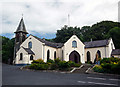
St Joseph's, Hannahstown
RC church high up in Hannahstown on the south-western edges of greater Belfast. See also an almost identical picture taken at Image
Worship began in this area around land consecrated by a Fr Hugh O’Donnell in 1797. Land here was donated by a wealthy Catholic landowner called John Hamill - he originally donated one acre of land to be used as a cemetery; his wife Hannah later donated money for a small schoolhouse which was also used as the church (it is likely that the area became known as "Hannah's Town" as a result of this). The Hamill family have an impressive mausoleum in the churchyard - see Image Some thirty years later St Joseph's was erected here on land donated gratuitously by John McCance, a liberal-minded Protestant landowner of the district. The stone nave on the left is part of the original building which was extensively renovated in 1998. There is a bench mark at the bottom of the stone nave - see Image
Image: © Rossographer
Taken: 7 Jul 2010
0.18 miles
7
St Joseph's Chapel, Hannahstown
This is a Catholic church on high ground overlooking the Collin River. The road from which the image was taken is Hannahstown Hill.
Image: © Eric Jones
Taken: 19 May 2012
0.19 miles
8
St Joseph's Catholic Chapel, Hannahstown Hill
Image: © Eric Jones
Taken: 19 May 2012
0.19 miles