IMAGES TAKEN NEAR TO
Wellington Court, BELFAST, BT1 6HW
Introduction
This page details the photographs taken nearby to Wellington Court, BT1 6HW by members of the Geograph project.
The Geograph project started in 2005 with the aim of publishing, organising and preserving representative images for every square kilometre of Great Britain, Ireland and the Isle of Man.

There are currently over 7.5m images from over14,400 individuals and you can help contribute to the project by visiting https://www.geograph.org.uk
Image Map
Images are licensed for reuse under creativecommons.org/licenses/by-sa/2.0
Notes
- Clicking on the map will re-center to the selected point.
- The higher the marker number, the further away the image location is from the centre of the postcode.
Image Listing (3105 Images Found)
Images are licensed for reuse under creativecommons.org/licenses/by-sa/2.0
Image
Details
Distance
1

Ulsterbus, Belfast
An Ulsterbus Wright-bodied Volvo, between turns, in Upper Queen Street.
Image: © Albert Bridge
Taken: 30 Oct 2009
0.01 miles
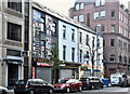
2
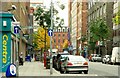
Upper Queen Street, Belfast
See Image Upper Queen Street is the continuation of Queen Street from Wellington Place to Howard Street (background). It has the usual mix of offices, shops and places to eat.
Image: © Albert Bridge
Taken: 12 Oct 2008
0.01 miles
3
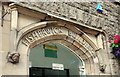
Former Church House, Belfast (13)
See Image The entrance from Upper Queen Street. For a closer view of the head on the right see Image
Image: © Albert Bridge
Taken: 9 Aug 2009
0.01 miles
4
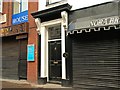
Doorway and shopfronts, Belfast
This doorway, at no 25 Howard Street Image, might be a survivor from the days before the street became entirely commercial. At the turn of the last century the southern side was commercial (mainly devoted to the linen and textile trades).
This (northern side) had houses and commercial premises. An exact comparison is not possible without comparing maps since there seems to have been a re-numbering. This might once have been 7, 9 or 11. If that is an accurate guess, then it was occupied by either a solicitor (upstairs in now a solicitor’s office), architect or dentist. The Bible House Image is on the left.
Image: © Albert Bridge
Taken: 22 Feb 2009
0.02 miles
5
Belfast: The Spires Centre
A modern conference facility in an old building.
Image: © Chris Downer
Taken: 11 Nov 2007
0.02 miles
6
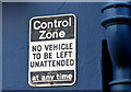
Surviving "control zone" sign, Belfast
See Image Skipper Street (February 2011). Another one – on this building Image at the corner of Upper Queen Street and Wellington Street. Failure to observe the sign meant that the street would be cleared and the army bomb disposal unit called. Delivery vehicles usually carried a full-time passenger who sat in the vehicle while the driver was absent. See also Image (Royal Avenue, July 2009).
Image: © Albert Bridge
Taken: 30 Jan 2013
0.02 miles
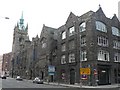
7
Nos 45-52 Upper Queen Street, Belfast - November 2016(1)
Nos 45-52 Upper Queen Street looking towards Wellington Street and Image
Image: © Albert Bridge
Taken: 20 Nov 2016
0.02 miles
8
Nos 45-52 Upper Queen Street, Belfast - November 2016(2)
Wellington Street is on the right.
Image: © Albert Bridge
Taken: 20 Nov 2016
0.02 miles
9
Howard Street
Looking west to Upper Queen Street.
Image: © Thomas Nugent
Taken: 1 Jun 2019
0.02 miles
10
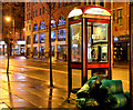
Nocturnal telephone box, Belfast
A BT telephone box, in Howard Street, accompanied by some commercial refuse awaiting collection.
Image: © Albert Bridge
Taken: 17 Feb 2014
0.02 miles