IMAGES TAKEN NEAR TO
Brooklands Road, BELFAST, BT16 2PE
Introduction
This page details the photographs taken nearby to Brooklands Road, BT16 2PE by members of the Geograph project.
The Geograph project started in 2005 with the aim of publishing, organising and preserving representative images for every square kilometre of Great Britain, Ireland and the Isle of Man.

There are currently over 7.5m images from over14,400 individuals and you can help contribute to the project by visiting https://www.geograph.org.uk
Image Map
Images are licensed for reuse under creativecommons.org/licenses/by-sa/2.0
Notes
- Clicking on the map will re-center to the selected point.
- The higher the marker number, the further away the image location is from the centre of the postcode.
Image Listing (23 Images Found)
Images are licensed for reuse under creativecommons.org/licenses/by-sa/2.0
Image
Details
Distance
1
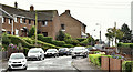
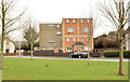
Brooklands Avenue, Dundonald (September 2016)
Part of the Ballybeen estate, close to the Upper Newtownards Road, built (like the Cregagh estate Image) using red brick.
Image: © Albert Bridge
Taken: 5 Sep 2016
0.11 miles
2
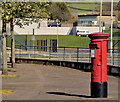
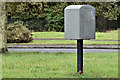
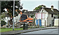
Pillar box, Dundonald
EIIR pillar box (BT16 782) at Brooklands Road, close to the Upper Newtownards Road (background).
Image: © Albert Bridge
Taken: 26 Mar 2012
0.12 miles
3
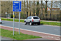
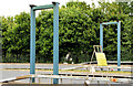
24-hour bus lane sign, Dundonald
A sign, on the Upper Newtownards Road, on the inward side of this footbridge Image, marking a short stretch of 24-hour bus lane. Most of the other bus lanes, between here and the city centre, have time restrictions.
Image: © Albert Bridge
Taken: 18 Apr 2013
0.13 miles
4
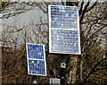
Solar panels, Dundonald (2)
Two solar panels, on the Upper Newtownards Road, on the inward side of this footbridge Image, powering the flashing lights on “school” signs.
Image: © Albert Bridge
Taken: 18 Apr 2013
0.14 miles
5
Refurbished flats, Ballybeen, Dundonald
Refurbished flats at the north eastern end of Davarr Avenue (middle left in Image). The remaining bit of brownish grey brick, popular in the late 1960’s/early 1970’s gives an indication of how they used to look. It was also common in railway platform shelters Image
Image: © Albert Bridge
Taken: 6 Mar 2014
0.14 miles
6
Absent footbridge, Ballybeen, Dundonald (July 2014)
See Image (May 2010). This prominent feature, on the Upper Newtownards Road, has been removed for eight weeks (from 5 July 2014) for refurbishment.
Image: © Albert Bridge
Taken: 18 Jul 2014
0.14 miles
7
Drop box, Ballybeen, Dundonald (September 2016)
A drop box at the Brooklands Road end of Brooklands Avenue Image
Image: © Albert Bridge
Taken: 5 Sep 2016
0.14 miles
8
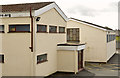
The Brooklands gospel centre, Dundonald (2)
See Image The western side.
Image: © Albert Bridge
Taken: 18 Apr 2013
0.14 miles
9
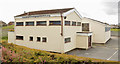
The Brooklands gospel centre, Dundonald (1)
A gospel centre, at Brooklands Crescent, which replaced a traditional wooden hut. The assembly was established, by the brethren in Dundonald gospel hall Image, to accommodate those who lived in the then-new Brooklands estate. The building opened (to the best of my knowledge) in 1972. This is the northern side. Image shows the western side.
Image: © Albert Bridge
Taken: 18 Apr 2013
0.15 miles
10
Nos 53-57 Davarr Avenue, Dundonald - September 2016(1)
The previous buildings, a row of former Housing Executive houses, were demolished last month.
Image: © Albert Bridge
Taken: 5 Sep 2016
0.15 miles