IMAGES TAKEN NEAR TO
Davarr Avenue, BELFAST, BT16 2NS
Introduction
This page details the photographs taken nearby to Davarr Avenue, BT16 2NS by members of the Geograph project.
The Geograph project started in 2005 with the aim of publishing, organising and preserving representative images for every square kilometre of Great Britain, Ireland and the Isle of Man.

There are currently over 7.5m images from over14,400 individuals and you can help contribute to the project by visiting https://www.geograph.org.uk
Image Map
Images are licensed for reuse under creativecommons.org/licenses/by-sa/2.0
Notes
- Clicking on the map will re-center to the selected point.
- The higher the marker number, the further away the image location is from the centre of the postcode.
Image Listing (86 Images Found)
Images are licensed for reuse under creativecommons.org/licenses/by-sa/2.0
Image
Details
Distance
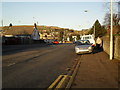
1
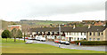
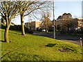
Green space, Ballybeen, Dundonald
There was a UK-wide (and possibly even throughout northern Europe) utopian idea, back in the 1960’s, that large greenfield housing estates should feature extensive areas of unused green space, both for their own sake and because they fulfilled an ideal of design and planning. The idea never really caught on with the residents and quietly dropped out of sight. Today’s drive is to rebuild the inner city at a lower density http://www.geograph.org.uk/snippet/5917.
This green space is at Davarr Avenue, Ballybeen.
Image: © Albert Bridge
Taken: 6 Mar 2014
0.05 miles
2
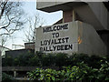
"Welcome to Loyalist Ballybeen"
The ever welcoming wall inscription on Drumadoon Drive.
Image: © Dean Molyneaux
Taken: 12 Feb 2010
0.07 miles
3
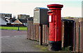
Pillar box and drop box, Dundonald
EIIR pillar box (BT16 369) and drop box, at the corner of Drumadoon Drive (foreground) and Davarr Avenue (Dunure Park on the Google map) in the Ballybeen estate.
Image: © Albert Bridge
Taken: 17 Mar 2012
0.07 miles
4
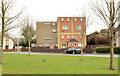
Refurbished flats, Ballybeen, Dundonald
Refurbished flats at the north eastern end of Davarr Avenue (middle left in Image). The remaining bit of brownish grey brick, popular in the late 1960’s/early 1970’s gives an indication of how they used to look. It was also common in railway platform shelters Image
Image: © Albert Bridge
Taken: 6 Mar 2014
0.08 miles
5
Loyalist mural, Morven Park, Ballybeen
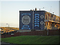
A mural of the Red Hand Commando (RHC) Youth 'C' Company - which was based in the estate. The RHC was effectively a branch of loyalist paramilitary group the Ulster Volunteer Force - both of which were outlawed in 1973. The RHC were responsible for 12 civilian deaths and decommissioned their weapons in June 2009.
"Lamh Dearg Abú" is in fact an Irish Gaelic expression meaning "up the Red Hand [of Ulster]".
Image: © Dean Molyneaux
Taken: 12 Feb 2010
0.08 miles
6
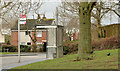
Drumadoon bus stop, Ballybeen, Dundonald
A Metro stop and shelter, at Drumadoon Drive, in the Ballybeen estate.
Image: © Albert Bridge
Taken: 6 Mar 2014
0.09 miles
7
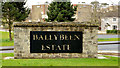
"Ballybeen estate" sign, Dundonald
A “welcome” sign, at Davarr Avenue/Craignish Crescent, close to the entrance to the Ballybeen estate
Image: © Albert Bridge
Taken: 6 Mar 2014
0.09 miles
8
Drumadoon Drive, Ballybeen
The main entrance from Robbs Road into the Ballybeen Estate.
Image: © Dean Molyneaux
Taken: 12 Feb 2010
0.10 miles
9
Robbs Road, Dundonald
Named after the Robb family which occupied Ballybeen House (now under a housing estate). It links the Upper Newtownards Road with the Church Road.
Image: © Dean Molyneaux
Taken: 12 Feb 2010
0.11 miles
10
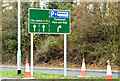
New park and ride direction sign, Dundonald (December 2014)
A new direction sign, on the Upper Newtownards Road, approaching the Robb’s Road/Dunlady Road crossroads. The junction has been changed (with revised traffic signalling Image) to improve access to the park and ride car park.
Image: © Albert Bridge
Taken: 1 Dec 2014
0.12 miles