IMAGES TAKEN NEAR TO
Robbs Road, BELFAST, BT16 2NA
Introduction
This page details the photographs taken nearby to Robbs Road, BT16 2NA by members of the Geograph project.
The Geograph project started in 2005 with the aim of publishing, organising and preserving representative images for every square kilometre of Great Britain, Ireland and the Isle of Man.

There are currently over 7.5m images from over14,400 individuals and you can help contribute to the project by visiting https://www.geograph.org.uk
Image Map
Images are licensed for reuse under creativecommons.org/licenses/by-sa/2.0
Notes
- Clicking on the map will re-center to the selected point.
- The higher the marker number, the further away the image location is from the centre of the postcode.
Image Listing (139 Images Found)
Images are licensed for reuse under creativecommons.org/licenses/by-sa/2.0
Image
Details
Distance
1
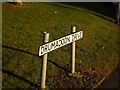
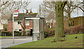
Sign, Drumadoon Drive, Ballybeen
At the junction with Robbs Road.
Image: © Dean Molyneaux
Taken: 12 Feb 2010
0.03 miles
2
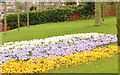
Spring flowerbed, Dundonald
A display of crocuses/croci on Robb’s Road, near the corner of Drumadoon Drive.
Image: © Albert Bridge
Taken: 6 Mar 2014
0.03 miles
3
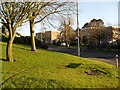
Drumadoon Drive, Ballybeen
The main entrance from Robbs Road into the Ballybeen Estate.
Image: © Dean Molyneaux
Taken: 12 Feb 2010
0.04 miles
4

Demolition work, Dundonald (April 2014)
Demolition work underway, on the Upper Newtownards Road, between Robb’s Road and Burton Avenue (right).
Image: © Albert Bridge
Taken: 30 Apr 2014
0.07 miles
5
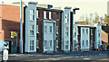
Ballybeen social apartments site, Dundonald - February 2016(1)
The new apartments at the middle of the site.
Image: © Albert Bridge
Taken: 10 Feb 2016
0.07 miles
6
Drumadoon bus stop, Ballybeen, Dundonald
A Metro stop and shelter, at Drumadoon Drive, in the Ballybeen estate.
Image: © Albert Bridge
Taken: 6 Mar 2014
0.07 miles
7
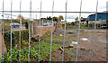
Development site, Dundonald (3)
A cleared but still undeveloped site, at the corner of the Upper Newtownards Road (left) and Burton Avenue, to which the following applies “Y/2006/0215/F 1027-1035 Upper Newtownards Road (odd numbers only), Ballyregan, Dundonald, Northern Ireland, BT16 1RN Redevelopment to include 32 No. 2 bedroom and 3 No. 1 bedroom apartments with associated site works and car parking Redevelopment to include 32 No. 2 bedroom and 3 No. 1 bedroom apartments with associated site works and car parking PERMISSION HAS BEEN GRANTED 18/08/2006”.
Note added on 6 December 2012: this site is now the subject of the following application for planning permission: “0304/F 1027-1035 Upper Newtownards Road (odd numbers only) Ballybeen , Dundonald Erection of social housing scheme of 32 No apartments in 2 No blocks (to include 20 No. 3 person 2 bed category 1 (active elderly) and 12 No. 3 person 2 bed generic needs) with associated parking and ancillary works”. This photograph appears as a matter of record only and does not express any opinion about the application.
Image: © Albert Bridge
Taken: 29 Oct 2012
0.07 miles
8
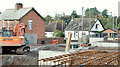
Ballybeen social apartments site, Dundonald - October 2014(1)
The view from the Upper Newtownards Road towards Burton Avenue – work is now underway on the foundations.
Image: © Albert Bridge
Taken: 11 Oct 2014
0.07 miles
9

Ballybeen social apartments site, Dundonald (June 2014)
The site cleared, pending start of construction.
Image: © Albert Bridge
Taken: 28 Jun 2014
0.07 miles
10
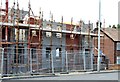
Ballybeen social apartments site, Dundonald (June 2015)
Apartments under construction at the Burton Avenue end of the site.
Image: © Albert Bridge
Taken: 20 Jun 2015
0.07 miles