IMAGES TAKEN NEAR TO
Old Church Square, BELFAST, BT16 2FD
Introduction
This page details the photographs taken nearby to Old Church Square, BT16 2FD by members of the Geograph project.
The Geograph project started in 2005 with the aim of publishing, organising and preserving representative images for every square kilometre of Great Britain, Ireland and the Isle of Man.

There are currently over 7.5m images from over14,400 individuals and you can help contribute to the project by visiting https://www.geograph.org.uk
Image Map
Images are licensed for reuse under creativecommons.org/licenses/by-sa/2.0
Notes
- Clicking on the map will re-center to the selected point.
- The higher the marker number, the further away the image location is from the centre of the postcode.
Image Listing (41 Images Found)
Images are licensed for reuse under creativecommons.org/licenses/by-sa/2.0
Image
Details
Distance
1
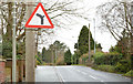
The Grahamsbridge Road, Dundonald
A suburban road running off the Comber Road.
Image: © Albert Bridge
Taken: 6 Mar 2014
0.02 miles
2
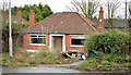
No 47 Grahamsbridge Road, Dundonald
Image: © Albert Bridge
Taken: 6 Mar 2014
0.06 miles
3
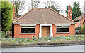
No 47 Grahamsbridge Road, Dundonald (November 2014)
See Image (March 2014). The same bungalow, with the grounds tidied but still vacant.
Image: © Albert Bridge
Taken: 28 Nov 2014
0.06 miles
4
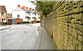
Wall and road, Dundonald
A slightly curved boundary wall, on the northern side of the Church Road, approaching the Grahamsbridge Road Image
Image: © Albert Bridge
Taken: 6 Mar 2014
0.09 miles
5
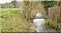
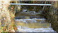
The Enler River, Dundonald (March 2014)
The Enler River, looking upstream from this footbridge Image
Image: © Albert Bridge
Taken: 6 Mar 2014
0.12 miles
6
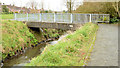
Footbridge, Dundonald (4)
One of several footbridges, locally, across the Enler River. This one is near the Comber Road pumping station, on the upstream side of Graham’s Bridge.
Image: © Albert Bridge
Taken: 6 Mar 2014
0.13 miles
7
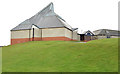
Dundonald Methodist church, Ballybeen
Dundonald Methodist church http://www.dundonaldmethodist.org/ built in 1969, on an elevated site, at Inchmarnock Drive in the Ballybeen estate.
Image: © Albert Bridge
Taken: 6 Mar 2014
0.13 miles
8
The Enler River, Dundonald (3)
The Enler, immediately downstream from the confluence Image
Image: © Albert Bridge
Taken: 22 Nov 2012
0.14 miles
9
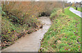
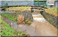
Stream, Moat Park, Dundonald (October 2014)
The stream on the right in Image in full flow after very heavy overnight rain.
Image: © Albert Bridge
Taken: 6 Oct 2014
0.14 miles
10
Confluence, Dundonald
The confluence, in Moat Park, of two streams – this one Image (left) and Image to form the Enler River Image Both are fast and muddy after heavy rain overnight.
Image: © Albert Bridge
Taken: 22 Nov 2012
0.14 miles