IMAGES TAKEN NEAR TO
Enler Park West, BELFAST, BT16 2DS
Introduction
This page details the photographs taken nearby to Enler Park West, BT16 2DS by members of the Geograph project.
The Geograph project started in 2005 with the aim of publishing, organising and preserving representative images for every square kilometre of Great Britain, Ireland and the Isle of Man.

There are currently over 7.5m images from over14,400 individuals and you can help contribute to the project by visiting https://www.geograph.org.uk
Image Map
Images are licensed for reuse under creativecommons.org/licenses/by-sa/2.0
Notes
- Clicking on the map will re-center to the selected point.
- The higher the marker number, the further away the image location is from the centre of the postcode.
Image Listing (37 Images Found)
Images are licensed for reuse under creativecommons.org/licenses/by-sa/2.0
Image
Details
Distance
1
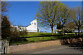
Millar's Lane
Christ Church (Presbyterian) overlooking Millar's Lane.
Image: © Robert Ashby
Taken: 22 Apr 2015
0.07 miles
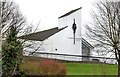
2
Christ Church, Dundonald - October 2014(1)
See Image (November 2012). A better view (in sunshine) to highlight the church’s bold outlines and stained glass wall. Image shows the lychgate.
Image: © Albert Bridge
Taken: 6 Oct 2014
0.08 miles
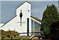
3
Christ Church, Dundonald
A Presbyterian church, at Millar’s Lane, completed in 1965 when Dundonald was expanding from a village to a suburb of Belfast. A time when Rolls Royce was a major local employer. Continue to Image
Image: © Albert Bridge
Taken: 22 Nov 2012
0.08 miles
4
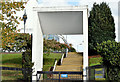
Christ Church, Dundonald - October 2014(2)
See Image A structure, at Millar’s Lane (Enler Close on the Google map), which (I think) the architect designed as a late 20th century lychgate http://en.wikipedia.org/wiki/Lychgate.
Image: © Albert Bridge
Taken: 6 Oct 2014
0.10 miles
5
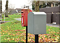
Drop and letter box, Dundonald
Drop box and post-mounted EIIR letter box (BT16 684), at Millar’s Lane, close to Enler Park.
Image: © Albert Bridge
Taken: 22 Nov 2012
0.10 miles
6
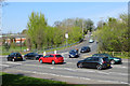
Busy junction
Where the Comber Road meets Grahamsbridge Road.
Image: © Robert Ashby
Taken: 22 Apr 2015
0.11 miles
7
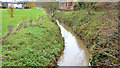
The Enler River, Dundonald (4)
The Enler, looking upstream towards the confluence Image, at Graham’s Bridge.
Image: © Albert Bridge
Taken: 22 Nov 2012
0.11 miles
8
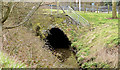
Graham's Bridge, Dundonald
The present Graham’s Bridge, carrying the Grahamsbridge Road Image across the Enler, is little more than a culvert. This view is downstream after which the river reaches another bridge at Millmount Image
Image: © Albert Bridge
Taken: 6 Mar 2014
0.12 miles
9
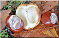
Chestnuts, Dundonald (October 2014)
Fallen chestnuts and shell beside the Comber Greenway.
Image: © Albert Bridge
Taken: 6 Oct 2014
0.12 miles
10
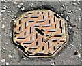
Octagonal access cover, Dundonald
A small octagonal access cover on the Grahamsbridge Road, opposite Millar’s Lane. No maker's name or purpose shown just “HCB 44”. Further information welcome.
Image: © Albert Bridge
Taken: 6 Oct 2014
0.12 miles