IMAGES TAKEN NEAR TO
Park Avenue, BELFAST, BT16 2AJ
Introduction
This page details the photographs taken nearby to Park Avenue, BT16 2AJ by members of the Geograph project.
The Geograph project started in 2005 with the aim of publishing, organising and preserving representative images for every square kilometre of Great Britain, Ireland and the Isle of Man.

There are currently over 7.5m images from over14,400 individuals and you can help contribute to the project by visiting https://www.geograph.org.uk
Image Map
Images are licensed for reuse under creativecommons.org/licenses/by-sa/2.0
Notes
- Clicking on the map will re-center to the selected point.
- The higher the marker number, the further away the image location is from the centre of the postcode.
Image Listing (121 Images Found)
Images are licensed for reuse under creativecommons.org/licenses/by-sa/2.0
Image
Details
Distance
1

"TOP" petrol station, Dundonald (April 2016)
A “TOP” (Tedcastles Oil Products Limited) petrol station on the Comber Road. The company is the owner of the “Kellys” name Image
Image: © Albert Bridge
Taken: 27 Apr 2016
0.02 miles
2
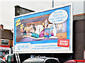
Phoenix Gas poster, Dundonald (September 2014)
See Image The Phoenix Gas posters have returned. This one, on a theme of boiler replacement, is at Park Drive. Continue to Image
Image: © Albert Bridge
Taken: 25 Sep 2014
0.04 miles
4
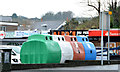
Recycling bins, Dundonald
Recycling bins in a car park on the Cumberland Road.
Image: © Albert Bridge
Taken: 29 Jan 2014
0.06 miles
5
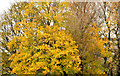
Last of the autumn leaves, Dundonald (2)
The last of the autumn leaves, in the park, close to Park Avenue and Park Drive.
Image: © Albert Bridge
Taken: 27 Nov 2013
0.06 miles
6
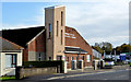
Pentecostal church, Dundonald
The Assembly of God Pentecostal church http://www.agireland.org/# on the Comber Road.
Image: © Albert Bridge
Taken: 1 Nov 2013
0.06 miles
7
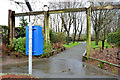
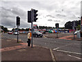
Park entrance, Dundonald
A doggy bin, at one of the entrances to Moat Park, on the Comber Road.
Image: © Albert Bridge
Taken: 29 Jan 2014
0.07 miles
8
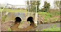
Culvert, Dundonald
A culvert, under the East Link Road, in Moat Park, beside the confluence of two streams (not named on the 1:12,000 map). After merging they continue as shown in Image to join the Enler River.
Image: © Albert Bridge
Taken: 18 Apr 2013
0.09 miles
9
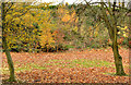
Last of the autumn leaves, Dundonald (1)
The last of the autumn leaves, in the park, close to the East Link Road.
Image: © Albert Bridge
Taken: 27 Nov 2013
0.09 miles
10
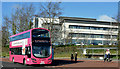
Metro bus, Dundonald (February 2016)
A Metro Wright-bodied Volvo (1298 SFZ 9398) departing the Ulster Hospital stop, on the Upper Newtownards Road, with the 10.27 Donegall Square West – Ballybeen (service 4A) via the Albert Bridge.
Image: © Albert Bridge
Taken: 10 Feb 2016
0.10 miles