IMAGES TAKEN NEAR TO
Comber Road, BELFAST, BT16 2AH
Introduction
This page details the photographs taken nearby to Comber Road, BT16 2AH by members of the Geograph project.
The Geograph project started in 2005 with the aim of publishing, organising and preserving representative images for every square kilometre of Great Britain, Ireland and the Isle of Man.

There are currently over 7.5m images from over14,400 individuals and you can help contribute to the project by visiting https://www.geograph.org.uk
Image Map
Images are licensed for reuse under creativecommons.org/licenses/by-sa/2.0
Notes
- Clicking on the map will re-center to the selected point.
- The higher the marker number, the further away the image location is from the centre of the postcode.
Image Listing (122 Images Found)
Images are licensed for reuse under creativecommons.org/licenses/by-sa/2.0
Image
Details
Distance
1
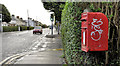
Letter box, Dundonald
Post-mounted EIIR letter box, on the Comber Road, at the corner of Grand Prix Park Image
Image: © Albert Bridge
Taken: 25 Nov 2011
0.01 miles
2
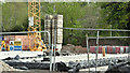
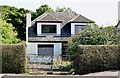
Nos 104 - 118 Comber Road, Dundonald (May 2017)
Work started on the foundations.
Image: © Albert Bridge
Taken: 1 May 2017
0.02 miles
3
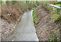
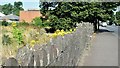
Bridge and culvert, Dundonald
The bridge carrying the Comber Road across this stream Image The section behind me is culverted back to the Eastlink Road.
Image: © Albert Bridge
Taken: 29 Jan 2014
0.02 miles
4
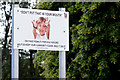
Dog dirt sign, Dundonald
An explicit sign close to the Moat Park playing fields on the Comber Road.
Image: © Albert Bridge
Taken: 28 Jun 2014
0.02 miles
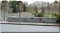
5
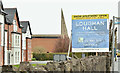
Loughan Hall, Dundonald - March 2019(2)
The completed development. Image shows the site before work started. The stone wall is a common reference point.
Image: © Albert Bridge
Taken: 19 Mar 2019
0.02 miles
6
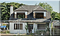
No 118 Comber Road, Dundonald (August 2016)
Preparing the premises for demolition.
Image: © Albert Bridge
Taken: 16 Aug 2016
0.02 miles
7
Stream, Dundonald - January 2014
See Image (November 2011). The same stream, seen from here Image, showing the effects of recent rain.
Image: © Albert Bridge
Taken: 29 Jan 2014
0.02 miles
8
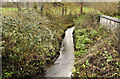
Stream, Dundonald
A stream (not named on the 1:12,000 map) flowing under the Comber Road, into the Enler River Image, a short distance to the south east. Continue to Image Image shows it at a higher level.
Image: © Albert Bridge
Taken: 25 Nov 2011
0.03 miles
9
No 118 Comber Road, Dundonald (August 2015)
No 118 Comber Road, Dundonald (boarded up).
Image: © Albert Bridge
Taken: 13 Aug 2015
0.03 miles
10
Vacant site, Comber Road, Dundonald - August 2015 (2)
Image: © Albert Bridge
Taken: 13 Aug 2015
0.03 miles